
CPLP of the sea: towards a Lusophone Maritime Spatial Data Infrastructure (LMSDI)

Abstract. This article explores the potential of a Lusophone Maritime Spatial Data Infrastructure (LMSDI) to enhance geospatial cooperation among Portuguese-speaking countries. Grounded in bibliographic and documentary analysis, the study examines how shared oceanic heritage and spatial data interoperability can support marine governance across the CPLP. It proposes the development of a Lusophone Geoportal for monitoring Exclusive Economic Zones, promoting environmental enforcement, and advancing the blue economy through digital integration and multilateral collaboration.
Key words: Exclusive Economic Zones, blue economy, spatial data infrastructure, Lusophony, maritime governance.
1. Introduction
The Portuguese language constitutes a foundational element of the Community of Portuguese-Language Countries (CPLP), serving as a common basis for political, economic, and scientific cooperation among nations spanning four continents. Since the establishment of the first oceanic routes in the fifteenth century by navigators such as Vasco da Gama (1469–1524), the language has spread across seas and territories, giving rise to a global linguistic space through which also circulate normative frameworks, administrative practices, and territorial governance models (Romaine, 2009; Mowbray, 2012; Tabory, 1975; Núñez, 2013). Nonetheless, despite the CPLP’s vast and strategic maritime presence, it still lacks integrated mechanisms for surveillance, monitoring, and the shared management of its oceanic spaces.
Control over maritime routes and naval infrastructure has historically been central to the projection of power. In the 21st century, this logic has extended to outer space, where satellites ensure communication, positioning, and Earth observation. The convergence between maritime and spatial domains has a direct impact on security, trade, and environmental monitoring, further deepening technological asymmetries among States (Bueger and Liebetrau, 2023; Pekkanen et al., 2022; Porter and Porter, 2024).
Contemporary ocean governance increasingly demands the capacity to integrate remote sensing, meteorological data, and orbital imagery to forecast extreme events, safeguard fishery resources, and combat illicit activities such as maritime trafficking and illegal fishing (Ilcev, 2024; Spanier and Kuenzer, 2024; Dolce et al., 2020). For CPLP countries with extensive Exclusive Economic Zones (EEZs) yet uneven institutional capacities, such requirements pose both geopolitical and technical challenges.
In this context, Marine Spatial Planning (MSP) offers an approach capable of articulating spatial technologies with national and international legal frameworks, promoting data interoperability, evidence-based environmental management, and digital sovereignty. This article proposes the creation of a Lusophone Maritime Spatial Data Infrastructure (LMSDI) as an integrated solution to support the CPLP in establishing a cooperative model of data-driven ocean governance (Shabbir et al., 2019).
The methodology adopted in this article is based on comparative documentary and bibliographic analysis, combining legal, institutional, and technological dimensions to support the proposal of the LMSDI. The study examines national experiences in the implementation of Marine Spatial Planning, identifies key interoperability gaps, and advances a regional solution focused on the development of a shared geoportal among CPLP member states. Expected outcomes include: the integration of databases concerning Exclusive Economic Zones; the strengthening of technical and normative cooperation among member states; and the consolidation of a strategic joint presence in the Atlantic and Indian Oceans, with enhanced digital sovereignty, environmental security, and governance of the blue economy.
Initiatives such as the European Union’s Marine Spatial Planning framework and the United Nations Committee of Experts on Global Geospatial Information Management (UN-GGIM)[1] have adopted integrated formats, combining technical architecture with multilevel governance models – as exemplified by Directive 2014/89/EU on Maritime Spatial Planning[2] and Directive 2007/2/EC, which established the Infrastructure for Spatial Information in the European Community (INSPIRE).[3] Drawing on these precedents, this article proposes a solution adapted to the Lusophone context, recognising that the feasibility of a shared infrastructure such as the LMSDI depends simultaneously on the definition of operational standards and the institutional alignment of member states. As such, the text is not purely descriptive or normative in nature, but rather propositional, seeking to articulate data policy and technical planning as inseparable components of a unified strategic agenda.
2. Context and foundations
2.1. The Community of Portuguese-Language Countries (CPLP) and the maritime dimension
The Community of Portuguese-Language Countries (CPLP) is an intergovernmental organisation founded in 1996, comprising Angola, Brazil, Cape Verde, Guinea-Bissau, Equatorial Guinea, Mozambique, Portugal, São Tomé and Príncipe, and Timor-Leste, in addition to a number of observer states. Its activities span a range of domains – including education, security, environment, and economy – with the overarching aim of deepening political and institutional coordination among its member states (Medeiros and Pinto, 2023).
In the maritime domain, the CPLP holds a significant presence across the Atlantic and Indian Oceans, exercising jurisdiction over vast Exclusive Economic Zones (EEZs). The management of these spaces entails shared challenges concerning resource exploitation, maritime security, and the monitoring of illegal activities (Duarte et al., 2024). Strengthening cooperation among Lusophone countries in this field could enhance their collective international engagement, bolstering mechanisms for surveillance and the sustainable use of marine resources (Hanenberg, 2021).
The principal economic activities conducted within CPLP maritime spaces include fishing, hydrocarbon extraction, deep-sea mining, and the development of marine biotechnology (Pavia, 2015). While the degree of dependence on these sectors varies across countries, the management of fishery resources and the mitigation of environmental impacts are shared concerns. Effective governance in this regard requires mechanisms for continuous monitoring, technological oversight, and prompt responses to illegal practices that threaten both marine ecosystems and food security (Fernandes, 2018).
CPLP member states also exhibit varying degrees of definition and recognition of their maritime boundaries. In some cases, such as Timor-Leste, unresolved negotiation processes continue to generate uncertainty (Pacheco, 2024). Currently, CPLP maritime spaces comprise approximately 196,701 sq. km of internal and archipelagic waters, 350,430 sq. km of territorial sea, and 7,347,355 sq. km of EEZ. Brazil, Mozambique, and Portugal account for the largest shares of territorial waters, while Brazil, Portugal, and Cape Verde possess the most extensive EEZs.
The total estimated water volume across CPLP maritime spaces amounts to approximately 24,133 billion cubic metres. In most cases, the continental shelf extends up to 200 nautical miles, overlapping with the EEZ. However, only a subset of countries has submitted formal claims for extension beyond this limit. Among these are Portugal, Brazil, and a joint submission by Cape Verde and Guinea-Bissau. The total claimed area for extended continental shelf amounts to approximately 5,554,841 sq. km (Pacheco, 2024).
With regard to maritime search and rescue (SAR), five CPLP countries – Angola, Brazil, Cape Verde, Mozambique, and Portugal – hold internationally recognised responsibilities, with designated zones totalling approximately 24,960,534 sq. km. The largest areas under SAR jurisdiction are overseen by Brazil, Portugal, and Angola. Considering all areas of sovereignty, jurisdiction, territorial claims, and operational obligations, the maritime spaces under CPLP responsibility encompass a substantial portion of the Atlantic and Indian Oceans.
Despite disparities in territorial extent and technical capacity, CPLP countries share structural challenges in protecting biodiversity, ensuring the sustainable use of marine resources, and combating illicit activities. These commonalities underscore the need for enhanced integration of surveillance systems and data sharing mechanisms (Leandro and Martínez-Galán, 2023). In this context, the blue economy – anchored in ocean energy, sustainable tourism, and marine biotechnology – emerges as a shared agenda with significant growth potential (Cardoso, 2023). The alignment of maritime policies with spatial technologies will depend on the consolidation of a regional infrastructure for ocean observation and governance, capable of addressing asymmetries through cooperation and system interoperability (Ashby, 2017), enabling the CPLP to evolve from a linguistic community to a jointly operational maritime presence (Pavia, 2015).
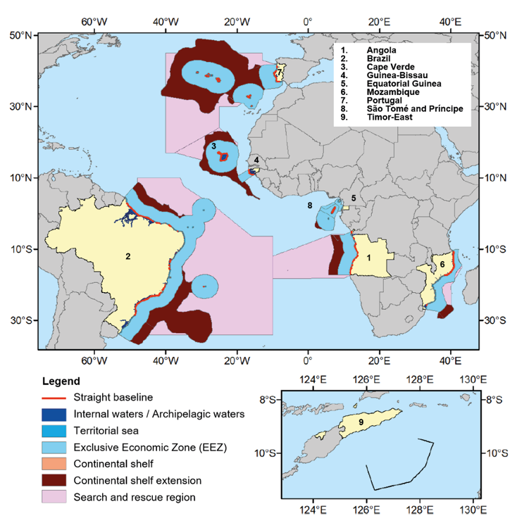
Source: adapted from Pacheco (2024).
Integrating satellites and remote sensors into national maritime governance can enhance data-driven decision-making in fisheries management, environmental monitoring, and responses to extreme events (Duarte, Albuquerque and Tavares, 2024), thereby reinforcing a shared geospatial identity and expanding the cooperative engagement of Lusophone countries in ocean governance.
On the basis of this vision, the CPLP is well positioned to structure itself as a coordinated maritime bloc, guided by data-informed governance and interoperable technologies. In this model, the sea ceases to be merely a symbolic interface among nations and becomes a geopolitical space endowed with shared analytical, operational, and normative capacities (Leandro and Li, 2023).
2.2. Maritime Spatial Planning (MSP): Concept and applications
Maritime Spatial Planning (MSP) may be defined as a model for organising the occupation and use of ocean spaces under the sovereignty, jurisdiction, or responsibility of a State. This model integrates maritime and space infrastructures and is grounded in the articulation between international maritime law, space law, and national legislation governing resource exploitation, surveillance, and the use of remote sensing technologies (Sutherland and Nichols, 2006).
The implementation of an MSP system within the context of the Community of Portuguese-Language Countries (CPLP) requires, at a minimum, the harmonisation of legal frameworks among member states. It also demands the establishment of regulatory mechanisms enabling the sharing of geospatial data and interoperability across technological systems for ocean observation and control (Ntona and Schröder, 2020).
MSP operates at the intersection of sovereign rights over Exclusive Economic Zones (EEZs) and the legal constraints placed on the use of outer space. The United Nations Convention on the Law of the Sea (UNCLOS) affirms the sovereign rights of coastal states over resources in their jurisdictional waters, while the 1967 Outer Space Treaty establishes the peaceful and non-appropriable nature of outer space. The deployment of sensors, satellites, and other orbital technologies in maritime monitoring thus requires a legal foundation that simultaneously upholds state autonomy and respects the principles of space law (Roe, 2023).
The institutional structure of MSP can vary. Potential models range from a coordinating technical agency with regulatory and operational functions to an intergovernmental consortium in which states retain full autonomy while adhering to cooperation commitments formalised through multilateral agreements (Meiner, 2010; Abramic et al., 2018). In the CPLP context, any institutional arrangement would need to be compatible with national legislation and capable of supporting both technical and legal interoperability (Rajabifard et al., 2006; Guerreiro, 2021).
MSP may also function as a tool for legal predictability and support the implementation of environmental regulations, licensing procedures, and fisheries monitoring. Harmonising legal frameworks with technological capacities enhances the precision with which biodiversity protection, fisheries regulation, and natural resource governance are enforced (Schaefer and Barale, 2011; Norton and Sarretta, 2023). Adherence to multilateral environmental treaties and the incorporation of international legal principles can strengthen the CPLP countries’ ability to engage effectively in relevant global forums (O’Connor and Cooper, 2024).
The effectiveness of environmental and climate monitoring relies heavily on the systematic collection of data regarding oceanic variables. The combination of ocean sensors with satellite data can support the identification of patterns in temperature, acidification, pollutant concentrations, and changes in marine currents (Klemas, 2013; Reggiannini et al., 2019). The ability to detect such variations in advance is fundamental for reducing risks to vulnerable ecosystems, such as coral reefs and mangroves, and for mitigating impacts on economic activities dependent on environmental stability (Mahrad et al., 2020).
This data is also relevant for the planning of responses to extreme weather events. Orbital imagery and predictive models can assist adaptation measures in coastal cities and port logistics (Rodger and Guida, 2020). Public policies aimed at coastal zoning and integrated coastal zone management can be more effectively grounded in such information (Schwartz-Belkin and Portman, 2023).
Fisheries monitoring faces operational limitations in CPLP countries, particularly due to the vast extent of their Exclusive Economic Zones (EEZs). Satellites can aid in identifying anomalous patterns in vessel movements, enabling the tracking of fleets and the automatic issuance of alerts in cases of illegal fishing or the use of prohibited techniques (Rowlands et al., 2019; Papadimitriou et al., 2019).
Beyond fisheries, other illicit activities on the high seas – such as smuggling and human trafficking – require the integration of operational data with behavioural analytics. The application of artificial intelligence to monitoring systems can enhance the identification of suspicious routes and support coordinated responses among CPLP States (Xing et al., 2014; Dineshbabu et al., 2019).
The use of space-based technologies in ocean governance includes remote sensors, maritime drones, and high-resolution satellite imagery. These tools are essential for the monitoring of economic activities, the safety of navigation, and responses to threats such as piracy and environmental degradation (Pandey and Kaneria, 2024; Pekkanen, Aoki and Mittleman, 2022). Their integration into an MSP system could enhance the effectiveness of maritime governance mechanisms, particularly in contexts with limited technical capacity.
International programmes offer transferable models applicable to the CPLP context. Initiatives led by the European Space Agency (ESA) and the United Nations demonstrate the use of orbital data for environmental surveillance, fisheries control, and maritime risk management. Adapting these methodologies to the specific legal and operational contexts of Lusophone countries may provide a robust foundation for structuring a tailored maritime spatial planning system (Muto et al., 2012; Racetin et al., 2022).
2.3. Legal and institutional foundations
The legal viability of Marine Spatial Planning (MSP) within the framework of the Community of Portuguese-Language Countries (CPLP) depends on its compatibility with international treaties governing the use of maritime and outer space domains. The United Nations Convention on the Law of the Sea (UNCLOS) sets parameters for the delimitation of maritime boundaries, the exploitation of resources, and cooperation in the monitoring of jurisdictional zones (Singh, 2022). The definition of Exclusive Economic Zones (EEZs), the regulation of resource extraction, and the dispute resolution mechanisms provided by UNCLOS form the foundational pillars of maritime governance (Mossop, 2018).
Additional international legal instruments complement this framework. The International Convention for the Prevention of Pollution from Ships (MARPOL) establishes environmental standards applicable to maritime navigation, while the International Ship and Port Facility Security Code (ISPS) defines maritime safety protocols (Bigagli, 2016; Spalding and de Ycaza, 2020). Integrating these frameworks into the structure of MSP may enhance legal certainty in enforcement, conservation, and licensing activities across oceanic areas under the responsibility of CPLP member states.
Aligning MSP with multilateral environmental agreements also broadens its potential for integration into international funding programmes. Instruments such as the Paris Agreement on climate change and the United Nations 2030 Agenda provide normative guidance for actions aimed at mitigating environmental risks, protecting marine biodiversity, and combating illegal fishing (von Schuckmann et al., 2020; Arora and Mishra, 2023). Coordination with these frameworks can support the eligibility of CPLP projects for access to multilateral funds targeting ocean governance and technological innovation.
Legal cooperation among member states may be formalised through bilateral or multilateral agreements governing the sharing of geospatial data, joint monitoring protocols, and the coordinated development of infrastructure. Experiences from regional organisations such as the African Union and Mercosur offer models of cooperative governance based on non-binding commitments and shared technical standards (Reynhardt, 2019; Talberg et al., 2018).
To support the technical implementation of MSP, the establishment of an institutional structure dedicated to inter-state coordination is advisable. A governance centre with a specific mandate could perform liaison functions with international bodies, standardise procedures, and monitor compliance with agreed protocols (Borgen, 2022). Such an arrangement may serve as a technical reference body and facilitate the flow of information among CPLP countries.
In contexts of legal diversity and institutional asymmetries, soft law mechanisms provide pragmatic alternatives to the rigidity of formal treaties. Technical guidelines, interoperability standards, and memoranda of understanding enable functional cooperation without requiring immediate legislative harmonisation (Byers, 2019). The adoption of soft law also supports the gradual integration of space technologies into national maritime monitoring systems, while respecting the specificities of each state. Technical cooperation agreements may promote the exchange of operational practices and the shared use of digital infrastructures. These instruments contribute to strengthening the institutional capacities of the CPLP and may enhance its ability to forge strategic partnerships within the context of the blue economy (Charles, 2014).
2.4. National case studies
The development of a maritime spatial data infrastructure within the framework of the Community of Portuguese-Language Countries (CPLP) can be informed by national experiences that, although heterogeneous, provide relevant examples of institutional organisation, technological application, and alignment with legal frameworks in the field of Marine Spatial Planning (MSP). Some countries have already established normative and operational instruments that contribute to shaping a model for regional integration.
In Portugal, MSP has been regulated since 2010 through the Plano de Situação do Ordenamento do Espaço Marítimo Nacional (PSOEM). The country was the first in the European Union to adopt a comprehensive plan that considers ecological, economic, and security aspects. Technical coordination is carried out by the National Maritime Authority and the Directorate-General for Natural Resources, Safety and Maritime Services, based on geospatial data produced and shared among governmental bodies and research centres (de Oliveira Ferreira, 2017). The Portuguese model is characterised by interinstitutional coordination, legal certainty, and the systematic use of space technologies in maritime spatial planning.
In Brazil, the policy of maritime spatial planning still reveals gaps in terms of integration between data repositories, regulatory frameworks, and strategic objectives. The Interministerial Commission for Marine Resources (CIRM) functions as a coordinating body, yet the operationalisation of MSP remains fragmented. Brazil’s Exclusive Economic Zone (EEZ) is one of the largest in the world, which presents significant challenges for surveillance and continuous monitoring. Initiatives such as the Blue Amazon Project and remote sensing systems developed by the Navy indicate the potential for linking MSP with space-based technologies for the purposes of enforcement and resource protection (Wiesebron, 2013).
On 26 March 2025, the United Nations Commission on the Limits of the Continental Shelf (CLCS) recognised Brazil’s extension of its continental shelf in the Equatorial Margin, adding approximately 360,000 sq. km to the country’s maritime territory – an area equivalent to that of Germany. Located between the states of Amapá and Rio Grande do Norte, this new zone extends beyond the 200-nautical-mile limit of the EEZ and borders the French Guiana, an overseas territory of the European Union.[4] The decision is the result of a technical/diplomatic process initiated in 2017 and coordinated by the Brazilian Navy under the Continental Shelf Survey Plan (LEPLAC), with the support of institutions such as Petrobras and the National Agency for Petroleum, Natural Gas and Biofuels (ANP). This constitutes a significant geopolitical advancement for Brazil, with strategic implications for the exploration of natural resources and the delimitation of sovereign maritime spaces in the North–South Atlantic.
In Cabo Verde, the National Maritime Spatial Planning Plan (PNOEM) was developed with the support of the FAO and the European Union. The country faces operational limitations, including a shortage of specialised human resources and the absence of integrated data platforms. Nevertheless, the plan prioritises fisheries management, biodiversity conservation, and the development of the blue economy (Madeira, 2023). The existing technical structure is compatible with future connections to the LMSDI and can offer useful inputs for defining regional standards.
Mozambique is currently at an early stage of structuring its Marine Spatial Planning system, with technical support from multilateral organisations. The main challenges include the lack of interoperability between databases, limited financial resources, and a scarcity of qualified technical staff. Nevertheless, initiatives focused on coastal mapping, marine conservation, and participatory management of protected areas have progressed through partnerships with universities and non-governmental organisations (Ceita and Ribeiro, 2020). Angola, in turn, has not yet implemented a formal and fully operational MSP system. In this context, both Mozambique and Angola present favourable conditions for a gradual approach to integration into the LMSDI, provided that this is supported by consistent investment in technical capacity building and digital infrastructure.
Taken together, these national case studies demonstrate that, despite significant differences in technical and institutional capacities, there are ongoing initiatives that may be articulated into a regional model of interoperability and data sharing. The consolidation of the LMSDI depends on the integration of space agencies, research centres, and maritime management authorities of the member states, grounded in reliable, up-to-date, and accessible data (Abreu, 2015; Antunes et al., 2022).
3. Technical proposal: Lusophone Maritime Spatial Data Infrastructure (LMSDI) and Lusophone Geoportal
The Lusophone Maritime Spatial Data Infrastructure (LMSDI) constitutes a technical integration proposal among CPLP countries, aimed at the collection, management, and analysis of spatial data relating to the maritime domain. The existence of a shared language reduces operational barriers and enables the construction of an interoperable architecture for georeferenced data (Varona, 2016). The functional foundation of the LMSDI involves the establishment of a Lusophone Geoportal, conceived as a centralised access point to data on Exclusive Economic Zones (EEZs), continental shelves, search and rescue areas, shipping corridors, and other components of Marine Spatial Planning (MSP). This geoportal will host thematic layers provided by national institutions, including data on fisheries, resource use, maritime traffic, and environmental variables (Ferreira et al., 2021; Oliveira Ferreira, 2017).
The technical structure for supplying data to the geoportal should mobilise hydrographic institutes, research centres, and space agencies from the member states, drawing upon remote sensing, satellite imagery, and maritime drones as primary data sources. These elements are to be processed using analytical tools based on geospatial modelling and scenario prediction, with applications in resource management, environmental monitoring, and coastal planning (Abreu, 2015; Antunes et al., 2022). The dissemination of information will be facilitated by standardised metadata protocols and interoperability between distributed databases.
Beyond the collection and dissemination of data, the LMSDI may incorporate a technical training module, developed in partnership with universities and research institutions from the CPLP. This module would include open-access courses, technical reports, repositories of best practices, and normative materials on MSP and geospatial technologies (Nunes et al., 2015; Sierra-Correa et al., 2020). The technical governance of the LMSDI could be assigned to a technical committee composed of representatives appointed by the member states, with responsibilities for defining minimum quality standards, monitoring the updating of national systems, and coordinating interactions between information producers and users (Cavallo et al., 2020).
The establishment of a shared database with access managed through permission levels would allow for the cross-referencing of information concerning maritime use, environmental conservation, and security. This, in turn, would facilitate the production of comparative diagnostics, risk analysis, and the formulation of evidence-based public policies (Fidélis et al., 2022).
4. Governance and cooperation models
The development of a Marine Spatial Planning (MSP) system within the CPLP requires alignment with the main treaties and international instruments governing the use of the oceans and outer space. The United Nations Convention on the Law of the Sea (UNCLOS) provides the legal foundations for the delimitation of maritime boundaries, the exploitation of resources, and interstate cooperation in jurisdictional waters (Singh, 2022). Complementary instruments such as the MARPOL Convention, the ISPS Code, and the Convention on Biological Diversity (CBD) contribute to the normative framework required for ocean governance (Mossop, 2018; Bigagli, 2016; Spalding and de Ycaza, 2020).
The following table presents a summary of relevant international agreements and their potential applications in the CPLP context:
Table 1. Summary of international legal instruments on the sea and possible applications to the CPLP
| Year | Legal instrument | Entity | Description | Application in CPLP |
|---|---|---|---|---|
| 1972 | International Convention for the Safety of Life at Sea (SOLAS) | International Maritime Organization (IMO) | Establishes minimum safety standards for vessels, including requirements for construction, equipment, and operations | Creation of an integrated maritime safety system among Lusophone countries |
| 1972 | London Convention on the Prevention of Marine Pollution by Dumping of Wastes and Other Matter | International Maritime Organization (IMO) | Regulates waste disposal into the ocean, preventing marine pollution from harmful substances | Establishment of joint regulations for waste disposal control in the Atlantic and Indian Oceans |
| 1973 | International Convention for the Prevention of Pollution from Ships (MARPOL) | International Maritime Organization (IMO) | Sets environmental rules to prevent pollution caused by ships and establishes international waste disposal standards | Harmonization of maritime pollution control policies among CPLP countries |
| 1979 | International Convention on Maritime Search and Rescue (SAR) | International Maritime Organization (IMO) | Defines cooperation between states for the search and rescue of vessels and crews in distress at sea | Cooperation between Lusophone navies and coast guards for search and rescue operations |
| 1982 | United Nations Convention on the Law of the Sea (UNCLOS) | United Nations (UN) | Defines maritime zones, navigation rights, and resource exploitation, while regulating coastal states’ jurisdiction over their waters | Definition of a common CPLP geospatial identity within the framework of the Law of the Sea |
| 1992 | Convention on Biological Diversity (CBD) | United Nations (UN) | Includes guidelines for the conservation of marine biodiversity and the sustainable use of ocean resources | Development of joint strategies for biodiversity protection in Lusophone EEZs |
| 1994 | Agreement on the Implementation of Part XI of UNCLOS | United Nations (UN) | Regulates mineral exploitation in the international seabed, ensuring a balance between economic development and environmental preservation | Scientific and technological cooperation for the sustainable exploration of seabed resources |
| 1995 | Agreement on Straddling Fish Stocks and Highly Migratory Fish Stocks | United Nations (UN) | Establishes guidelines for sustainable fishing and the conservation of migratory species, encouraging international cooperation | Coordination of policies for the sustainable management of fish stocks in the South Atlantic |
| 2001 | UNESCO Convention on the Protection of Underwater Cultural Heritage | UNESCO | Regulates the preservation of submerged archaeological sites, protecting historic shipwrecks and other underwater structures | Joint protection and mapping of Lusophone underwater cultural heritage |
| 2002 | International Ship and Port Facility Security (ISPS) Code | International Maritime Organization (IMO) | Establishes maritime security standards for ports and vessels, preventing illicit acts and threats to navigation | Development of common maritime security protocols for CPLP ports |
| 2018 | Nairobi Summit Agreement on Marine Plastic Pollution | United Nations Environment Programme (UNEP) | Aims to reduce plastic pollution in the oceans through waste control policies and incentives for the circular economy | Adoption of a joint program to combat plastic pollution in CPLP oceans |
Source: own work.
The coordinated application of these treaties may enhance the legal predictability of marine spatial planning (MSP) initiatives, facilitate access to international financing mechanisms, and strengthen engagement with multilateral organisations such as the United Nations (UN), the International Maritime Organization (IMO), the United Nations Educational, Scientific and Cultural Organization (UNESCO), and the United Nations Environment Programme (UNEP) (von Schuckmann et al., 2020; Arora and Mishra, 2023).
Legal cooperation among CPLP countries can be formalised through bilateral or multilateral agreements focused on the sharing of spatial data, the definition of technical protocols, and the development of joint infrastructure. Institutions such as the African Union and Mercosur provide relevant institutional models for shared governance and the formulation of supranational policies grounded in intergovernmental commitments (Reynhardt, 2019; Talberg et al., 2018).
The creation of a specific regulatory framework for Lusophone MSP may be guided by the progressive harmonisation of national legislation on matters such as environmental licensing, maritime enforcement, georeferenced data sharing, and the use of space-based technologies (Doorn and Veloso, 2023). To support the implementation of LMSDI and the broader MSP agenda, the establishment of a technical governance centre linked to the CPLP is recommended. This body would be responsible for international coordination, the definition of operational standards, and the assessment of national system compliance (Borgen, 2022).
The experience of institutions such as the International Maritime Organization (IMO) and the European Space Agency (ESA) provides valuable operational insights for the design of the model, enabling the adoption of international standards for ocean monitoring and risk management (Markiewicz-Stanny and SzuniewiczStępień, 2022). Normative coordination within the CPLP could initially take the form of soft law instruments – such as technical guidelines and memoranda of understanding – thus facilitating cooperation in settings marked by institutional asymmetries (Byers, 2019).
Finally, the establishment of a permanent technical forum among member states could promote joint projects in research, capacity-building, and monitoring, thereby enhancing the CPLP’s institutional and technical maturity in the use of space-based technologies applied to the marine domain. Strengthening national capacities and developing a shared legal foundation are both essential for positioning the Lusophone world as a credible actor in the global governance of the oceans (Charles, 2014).
5. Funding strategies
The implementation of Marine Spatial Planning (MSP) and the Lusophone Maritime Spatial Data Infrastructure (LMSDI) within the Community of Portuguese-Language Countries (CPLP) requires a funding strategy that is compatible with the fiscal, institutional, and technological diversity of the member states. This strategy must combine internal and external funding sources, integrating national budgets, multilateral financing, and public-private partnerships (Coker et al., 2020).
Multilateral development banks offer specific credit lines for projects related to technological innovation, digital transformation, and data-based territorial management. Institutions such as the African Development Bank (AfDB), Brazil’s National Bank for Economic and Social Development (BNDES), and the World Bank have programmes focused on the integration of space technologies and the strengthening of ocean monitoring capacities (Santos, 2023; Madeira, 2023). Negotiating dedicated agreements with these organisations could enable medium and long-term financing for the LMSDI and for the integration of national systems into global spatial data platforms (Leandro and Lobo, 2020).
The establishment of a CPLP Fund for the LMSDI, with proportional contributions from Member States and investments from international partners, could ensure the continuity of the system’s structural actions. This fund could be linked to ongoing multilateral programmes on digital transformation, environmental sustainability, and technological innovation (Cardoso, 2023). Decentralised management by a multilateral board would allow participating countries to define priorities and allocate resources according to their national agendas (Barros-Platiau and Barros, 2022).
Public-private partnerships (PPPs) represent a viable alternative for the development of technological solutions, particularly in remote sensing, data interoperability, and automated geospatial platform management. Companies in the aerospace sector, big data analytics, and specialised software development could contribute with technology and co-financing for the development of LMSDI modules. Technological concession models and cooperation contracts may expand access to advanced solutions, reduce operational costs, and accelerate the implementation of strategic components of the system (Ceita and Ribeiro, 2020).
The LMSDI can also be structured to align with international thematic funding mechanisms. Programmes such as the Green Climate Fund (GCF) and the Global Fund for the Oceans (GFO) prioritise projects focused on climate change adaptation, marine conservation, and digitalisation of ocean governance. Initiatives addressing illegal fishing, biodiversity protection, and environmental change monitoring may be eligible for these funding lines (Ventura et al., 2020).
The financial governance of the LMSDI could adopt a decentralised model, in which member states contribute in accordance with their fiscal capacity. The creation of a governing board with national representatives would enable joint administration of resources and ensure transparency in decision-making processes (Bernal et al., 2006). This structure would support the financial sustainability of the system and enable equitable participation of countries, even in the face of budgetary constraints, thereby contributing to the consolidation of a cooperative geospatial infrastructure (Leandro and Li, 2025).
6. Conclusion
The Portuguese language was born and expanded across the oceans, and it is precisely in the maritime domain that the geostrategic dimension of the Community of Portuguese-Language Countries (CPLP) becomes evident. However, this oceanic presence still lacks common mechanisms for technical, legal, and institutional coordination that would underpin a data-driven model of governance. The proposed creation of the Lusophone Maritime Spatial Data Infrastructure (LMSDI) offers an integrated response to this gap by combining interoperable technical standards with multilateral legal frameworks and a cooperative institutional architecture among member states.
Inspired by normative models such as Directive 2007/2/EC (INSPIRE), which establishes spatial data infrastructures in the European Union, and Directive 2014/89/EU, which defines a framework for Maritime Spatial Planning (MSP), the LMSDI applies these principles analogously to the Lusophone context. Similarly, it draws upon United Nations General Assembly Resolution A/RES/66/206, which recognises the United Nations Committee of Experts on Global Geospatial Information Management (UN-GGIM) as the technical body for global geospatial governance. By aligning with these established frameworks, the LMSDI positions itself as a normative and adaptable proposal, grounded in internationally recognised standards.
The consolidation of a Lusophone Geoportal as the operational interface of the LMSDI will allow for structured and shared access to critical geospatial data on Exclusive Economic Zones (EEZs), continental shelves, navigation corridors, and other areas of strategic common interest. This structure will enable evidence-based environmental management, enhance maritime security, and foster the blue economy, thereby reducing technical asymmetries and strengthening the digital sovereignty of the CPLP.
The viability of this model requires the mobilisation of financial resources, adherence to international standards, and the strengthening of national institutional capacities. The sharing of data, methodologies, and infrastructures among countries with varying levels of technical development promotes economies of scale, collective efficiency, and greater engagement of the CPLP in multilateral platforms for financing, science, and ocean governance.
The LMSDI is not merely a technical proposal; it is a political-normative arrangement rooted in solidarity, interoperability, and the strategic use of geoinformation by countries that share a common cultural heritage. Building a shared geospatial data base among Lusophone countries can reduce dependency on sensitive technologies, promote scientific diplomacy, and consolidate the CPLP as a relevant actor in the global regulation of maritime spaces. By applying internationally established normative experiences to the Lusophone context, the project reinforces technological equity and regional leadership in the digital transformation of the oceans.
Autorzy
REFERENCES
ABRAMIC, A., BIGAGLI, E., BARALE, V., ASSOULINE, M., LORENZO-ALONSO, A. and NORTON, C. (2018), ‘Maritime spatial planning supported by infrastructure for spatial information in Europe (INSPIRE)’, Marine Policy. https://doi.org/10.1016/j.ocecoaman.2017.11.007
ABRAMIC, A., NORTON, D., SARRETTA, A., MENEGON, S., KATSIKA, M., GEKAS, V. et al. (2023), Maritime Spatial Planning Data Framework (MSPdF). How to Structure Input Data for MSP Process, Monitoring & Evaluation, https://cinea.ec.europa.eu/system/files/2023-07/HZ-07-23-221-EN-N.pdf [accessed on: 25.05.2025].
ABREU, C. T. (2015), Brazilian coastal and marine protected areas importance, current status and recommendations, Division for Ocean Affairs and the Law of the Sea, Office of Legal Affairs, The United Nations, New York, https://www.un.org/oceancapacity/sites/www.un.org.oceancapacity/files/thesis_carina_abreu_31_12_pdf_1.pdf [accessed on: 25.05.2025].
ALENCAR MAYER FEITOSA VENTURA, V. (2020), ‘The Environmental Dimension of the “Brazilian Blue Amazon”: Environmental Rights and Duties on the Continental Shelf’, [in:] VENTURA, V. A. M. F. (ed.), Environmental Jurisdiction in the Law of the Sea: The Brazilian Blue Amazon, Cham: Springer, pp. 247–296. https://doi.org/10.1007/978-3-030-50543-1_9
ANTUNES, M., FIDÉLIS, T. and PIRES, M. L. (2022), ‘The Protection of Estuarine Margins under the Maritime–Terrestrial Public Domain: The Cases of Portugal, Angola, Brazil, and Mozambique’, Laws, 11 (2), p. 34. https://doi.org/10.3390/laws11020034
ARORA, N. K., MISHRA, I. and ARORA, P. (2023), ‘SDG 14: Life below water – viable oceans necessary for a sustainable planet’, Environmental Sustainability, 6 (4), pp. 433–439. https://doi.org/10.1007/s42398-023-00299-0
ASHBY, S. (2017), The Lusophone world: the evolution of Portuguese national narratives, Liverpool: Liverpool University Press. https://doi.org/10.2307/jj.3079209
BARROS-PLATIAU, A. F. and BARROS, J. G. C. (2022), ‘Brazil’s strategic diplomacy for maritime security and safety’, Contemporary Politics, 28 (1), pp. 38–54. https://doi.org/10.1080/13569775.2021.1968569
BERNAL, P. et al. (2006), Reports from the Third Global Conference on Oceans, Coasts, and Islands: Co-Chairs’ Report – Volume 2, Third Global Conference on Oceans, Coasts, and Islands, UNESCO, Paris, 23–28 January 2006, https://udspace.udel.edu/bitstream/19716/2509/1/ParisConferenceReports.pdf [accessed on: 25.05.2025].
BIGAGLI, E. (2016), ‘The international legal framework for the management of the global oceans social-ecological system’, Marine Policy, 68, pp. 155–164. https://doi.org/10.1016/j.marpol.2016.03.005
BORGEN, C. J. (2022), ‘Space Law and Diplomacy’, [in:] WOUTERS, J., RAUBE, K. and ODERMATT, J. (eds), Research Handbook on Law and Diplomacy, Cheltenham: Edward Elgar Publishing, https://www.elgaronline.com/edcollchap/book/9781789908473/book-part-9781789908473-24.xml [accessed on: 12.05.2025].
BUEGER, C. and LIEBETRAU, T. (2023), ‘Critical maritime infrastructure protection: What’s the trouble?’, Marine Policy, 155, 105772. https://doi.org/10.1016/j.marpol.2023.105772
BYERS, M. (2019), ‘Cold, dark, and dangerous: international cooperation in the Arctic and space’, Polar Record, 55 (1), pp. 32–47. https://doi.org/10.1017/S0032247419000160
CARDOSO, D. (2023), ‘«So Much Sea»: Opportunities and Challenges in Portugal-Brazil Maritime Cooperation’, [in:] CANOTILHO, J. and CUNHA, P. (eds), Portugal and the Lusophone World: Law, Geopolitics and Institutional Cooperation, Singapore: Springer, pp. 197–217. https://doi.org/10.1007/978-981-99-0455-6_11
CEITA, D. and DE ARAÚJO RIBEIRO, P. (2020), ‘An assessment of the impact of maritime (In)security in the Gulf of Guinea: special emphasis on Sao Tome and Principe’, World Maritime University Dissertations, https://commons.wmu.se/cgi/viewcontent.cgi?article=2382&context=all_dissertations [accessed on: 25.05.2025].
COKER, C., DJINADOU, M., EL HOUDAIGUI, R., EHLE, J., MOREIRA, J. A., NASCIMENTO, D. et al. (2020), Atlantic Centre for Defence Capacity Building, IDN Cadernos. https://comum.rcaap.pt/bitstream/10400.26/36884/1/idncadernos_38.pdf [accessed on: 25.05.2025].
DE OLIVEIRA FERREIRA, M. A. (2017), Evaluating performance of Portuguese Marine Spatial Planning (Doctoral dissertation, Universidade NOVA de Lisboa, Portugal), https://run.unl.pt/bitstream/10362/20611/1/Tese_Ferreira_2016.pdf [accessed on: 25.05.2025].
DINESHBABU, A. P., THOMAS, S., ROHIT, P. and MAHESWARUDU, G. (2019), ‘Marine spatial planning for resource conservation, fisheries management and for ensuring fishermen security – global perspectives and Indian initiatives’, Current Science, 116 (4), pp. 561–567. https://doi.org/10.18520/cs/v116/i4/561-567
DOLCE, F., DI DOMIZIO, D., BRUCKERT, D., RODRÍGUEZ, A. and PATRONO, A. (2020), ‘Earth observation for security and defense’, [in:] VIJ, R. and DUNN, L. (eds), Handbook of Space Security: Policies, Applications and Programs, Cham: Springer, pp. 705–731. https://doi.org/10.1007/978-3-030-23210-8_106
DRANKIER, P. (2012), ‘Embedding maritime spatial planning in national legal frameworks’, Journal of Environmental Policy & Planning, 14 (1), pp. 7–27. https://doi.org/10.1080/1523908X.2012.662381
DROMGOOLE, S. (2013), Underwater cultural heritage and international law, Cambridge: Cambridge University Press. https://files.pca-cpa.org/pcadocs/ua-ru/02.%20UA%20Observations%20on%20Jurisdiction/02.%20Legal%20Authorities/UAL-22.pdf [accessed on: 25.05.2025].
FERNANDES, J. L. J. (2018), ‘Portugal between Lusophony, the European Union and the rest of the world: Strategic challenges and multiterritoriality in the 21st century’, Méditerranée. Revue géographique des pays méditerranéens/Journal of Mediterranean geography, 130. https://doi.org/10.4000/mediterranee.10549
GARCIA, F. P. and RIBEIRO, S. (2023), ‘Lusophone Geopolitics: Blue Economy and Maritime Security in Contemporary Mozambique’s Geopolitics’, [in:] CANOTILHO, J. and CUNHA, P. (eds), Portugal and the Lusophone World: Law, Geopolitics and Institutional Cooperation, Singapore: Springer Nature Singapore, pp. 379–400. https://doi.org/10.1007/978-981-99-0455-6_19
GARCIA, S. M., RICE, J. and CHARLES, A. (2014), ‘Governance of marine fisheries and biodiversity conservation: Convergence or coevolution?’, [in:] GARCIA, S. M., RICE, J. and CHARLES, A. (eds), Governance of marine fisheries and biodiversity conservation: Interaction and coevolution, Oxford: Wiley-Blackwell, pp. 18–36. https://doi.org/10.1002/9781118392607.ch2
GUERREIRO, J. (2021), ‘The blue growth challenge to maritime governance’, Frontiers in Marine Science, 8, 681546. https://doi.org/10.3389/fmars.2021.681546
HANENBERG, L. L. (2021), ‘Lusophone Sea on a High Tide? The Current Role of Maritime Discourse in Public Governmental Speeches from Brazil, Cabo Verde, and Portugal’, ISCTE-IUL, CEI-IUL Working Paper, https://blog.cei.iscte-iul.pt/wp-content/uploads/2021/01/Lusophone-Sea-on-a-high-tide.pdf [accessed on: 25.05.2025].
ILCEV, D. S. (2024), ‘Infrastructure of Contemporary Maritime Communication, Navigation and Surveillance (CNS) System’, Degres, ISSN 0376-8163, https://degres.eu/wp-content/uploads/10-DEJ1395.pdf [accessed on: 25.05.2025].
KLEMAS, V. (2013), ‘Fisheries applications of remote sensing: An overview’, Fisheries Research, 148, pp. 124–136. https://doi.org/10.1016/j.fishres.2012.02.027
LAURO, A. and CORRÊA, C. R. (2022), ‘Futures for the Maritime Domain: Signs and Trends That Shape Scenarios’, [in:] GERMAN, R. (ed.), Power and the Maritime Domain, London: Routledge, pp. 286–301. https://doi.org/10.4324/9781003298984-23
LEANDRO, F. J. B. and LI, Y. (2025), ‘Global Partners Not Contiguous Neighbors: The Potential of Sino-Portuguese Cooperation’, [in:] LEANDRO, F. J. B. (ed.), The Palgrave Handbook on China-Europe-Africa Relations, Singapore: Springer Nature Singapore, pp. 101–138. https://doi.org/10.1007/978-981-97-5640-7_5
LEANDRO, F. B. J. and LOBO, A. (2020), ‘São Tomé and Príncipe: More than the land of cocoa and coffee’, China and the World: Ancient and Modern Silk Road, 3 (3), 2050006, https://repository.um.edu.mo/bitstream/10692/125852/1/2020-Sa%CC%83o%20Tome%CC%81%20and%20Pri%CC%81ncipe-More%20than%20the%20Land%20of%20Cocoa%20and%20Coffee.pdf [accessed on: 12.05.2025].
LEANDRO, F. J. B. and LI, Y. (2023), ‘The Spatial Development Initiatives: The Case of African Portuguese Speaking Countries’, [in:] CANOTILHO, J. and CUNHA, P. (eds), Portugal and the Lusophone World: Law, Geopolitics and Institutional Cooperation, Singapore: Springer Nature Singapore, pp. 239–273. https://doi.org/10.1007/978-981-99-0455-6_13
LEANDRO, F. J. B., MARTÍNEZ-GALÁN, E. and GONÇALVES, P. (2023), ‘The Portuguese-Speaking Small Island Developing States: Definition, Relevance, Commonalities and Specificities’, [in:] LEANDRO, F. J. B. (ed.), Portuguese-speaking Small Island Developing States: The Development Journeys of Cabo Verde, São Tomé and Príncipe, and Timor-Leste, Singapore: Springer Nature Singapore, pp. 25–91. https://doi.org/10.1007/978-981-99-3382-2_2
MADEIRA, J. P. (2023), ‘Cabo Verde’s Geopolitical Relevance in the Mid-Atlantic’, [in:] CANOTILHO, J. and CUNHA, P. (eds), Portugal and the Lusophone World: Law, Geopolitics and Institutional Cooperation, Singapore: Springer Nature Singapore, pp. 317–341. https://doi.org/10.1007/978-981-99-0455-6_16
MAHRAD, B. E., NEWTON, A., ICELY, J. D., KACIMI, I., ABALANSA, S. and SNOUSSI, M. (2020), ‘Contribution of remote sensing technologies to a holistic coastal and marine environmental management framework: a review’, Remote Sensing, 12 (14), 2313. https://doi.org/10.3390/rs12142313
MANN, I. (2016), Humanity at sea: maritime migration and the foundations of international law, Cambridge: Cambridge University Press, https://books.google.com/books?hl=en&lr=&id=yvsODQAAQBAJ [accessed on: 25.05.2025].
MARKIEWICZ-STANNY, J. and SZUNIEWICZ-STĘPIEŃ, M. (2022), ‘Irregular migration and its impact on the marine environment: Legal aspects’, Marine Policy, 144, 105216. https://doi.org/10.1016/j.marpol.2022.105216
MEDEIROS, S. E. and AYRES PINTO, D. J. (2023), ‘Lusophone Cooperation Frameworks and the Expansion of the Atlantic Maritime Security’, [in:] CANOTILHO, J. and CUNHA, P. (eds), Portugal and the Lusophone World: Law, Geopolitics and Institutional Cooperation, Singapore: Springer Nature Singapore, pp. 219–237. https://doi.org/10.1007/978-981-99-0455-6_12
MEINER, A. (2010), ‘Integrated maritime policy for the European Union – consolidating coastal and marine information to support maritime spatial planning’, Journal of Coastal Conservation, 14, pp. 1–11. https://doi.org/10.1007/s11852-009-0077-4
MOSSOP, J. (2018), ‘Can We Make the Oceans Greener: The Successes and Failures of UNCLOS as an Environmental Treaty’, Victoria University of Wellington Law Review, 49, p. 573. https://doi.org/10.26686/vuwlr.v49i4.5341
MOWBRAY, J. (2012), Linguistic Justice: International Law and Language Policy, Oxford: Oxford University Press, https://books.google.com/books?hl=en&lr=&id=H81HP2-OF0EC [accessed on: 25.05.2025].
MUTO, M., TSUNODA, T. and KUMASAKA, F. (2012), ‘Development of Marine Spatial Data Infrastructure in Japan’, GSDI 2012 Conference, Singapore, Mitsubishi Research Institute, Inc. & Japan Hydrographic Association, https://www.researchgate.net/profile/Masanori-Muto/publication/322630887 [accessed on: 25.05.2025].
NTONA, M. and SCHRÖDER, M. (2020), ‘Regulating oceanic imaginaries: the legal construction of space, identities, relations and epistemological hierarchies within marine spatial planning’, Maritime Studies, 19 (3), pp. 241–254. https://doi.org/10.1007/s40152-020-00163-5
NÚÑEZ, G. G. (2013), ‘Translating to communicate with linguistic minorities: state obligations under international law’, International Journal on Minority and Group Rights, 20 (3), pp. 405–441. https://doi.org/10.1163/15718115-02003004
O’CONNOR, H. M. and COOPER, J. A. G. (2024), ‘Coastal and Marine Management – Navigating islands of data’, Marine Policy, 169, 106279. https://doi.org/10.1016/j.marpol.2024.106279
PACHECO, M. B. (2024), Medidas da Terra e do Mar da CPLP – Apontamento (1ª ed.), Lisboa: Edições da Marinha / Instituto Hidrográfico, https://www.hidrografico.pt/recursos/files/Livro_completo_Apont.%20Medidas%20da%20Terra.pdf [accessed on: 25.05.2025].
PANDEY, S. K. and KANERIA, B. (2024), ‘The Use of Remote Sensing for Maritime Surveillance for Security and Safety’. [Manuscript]. [accessed on: 25.05.2025].
PAPADIMITRIOU, A., PANGALOS, K., DUVAUX-BÉCHON, I. and GIANNOPAPA, C. (2019), ‘Space as an enabler in the maritime sector’, Acta Astronautica, 162, pp. 197–206. https://doi.org/10.1016/j.actaastro.2019.06.017
PAVIA, J. F. L. Z. (2015), ‘The maritime security in the Gulf of Guinea, the energy security of Europe and the potential role of NATO and Portugal’, Energy, 8, 05, https://www.academia.edu/download/69382579/Maritime_Security_GG_06_2016.pdf [accessed on: 12.05.2025].
PEKKANEN, S. M., AOKI, S. and MITTLEMAN, J. (2022), ‘Small satellites, big data: uncovering the invisible in maritime security’, International Security, 47 (2), pp. 177–216. https://doi.org/10.1162/isec_a_00445
PIGOLA, A., DA COSTA, P. R., CARVALHO, L. C., SILVA, L. F. D., KNIESS, C. T. and MACCARI, E. A. (2021), ‘Artificial intelligence-driven digital technologies to the implementation of the sustainable development goals: A perspective from Brazil and Portugal’, Sustainability, 13 (24), 13669. https://doi.org/10.3390/su132413669
PORTER, M. and PORTER, T. (n.d.), ‘Global Navigation Satellite Systems Infrastructure, From the Personal to the Geopolitical’, SSRN, https://papers.ssrn.com/sol3/papers.cfm?abstract_id=5076425 [accessed on: 25.05.2025].
RACETIN, I., KILIĆ PAMUKOVIĆ, J. and ZRINJSKI, M. (2022), ‘Role of Marine Spatial Data Infrastructure and Marine Cadastre in a Sustainable World’, Journal of Marine Science and Engineering, 10 (10), 1407. https://doi.org/10.3390/jmse10101407
REGGIANNINI, M., RIGHI, M., TAMPUCCI, M., LO DUCA, A., BACCIU, C., BEDINI, L. et al. (2019), ‘Remote sensing for maritime prompt monitoring’, Journal of Marine Science and Engineering, 7 (7), 202. https://doi.org/10.3390/jmse7070202
REYNHARDT, M. (2019), Global Space Governance: Africa’s Contribution to the United Nations Committee on the Peaceful Uses of Outer Space (UNCOPUOS) (Master’s thesis, University of Pretoria, South Africa), https://search.proquest.com/openview/8a48374b453a3737b6576af589d70003 [accessed on: 25.05.2025].
RODGER, M. and GUIDA, R. (2020), ‘Classification-aided SAR and AIS data fusion for space-based maritime surveillance’, Remote Sensing, 13 (1), 104. https://doi.org/10.3390/rs13010104
ROE, M. (2023), ‘Outer Space Governance and the Maritime Context’, [in:] ROE, M. (ed.), Governance of the Global and Extra-Terrestrial Commons: What the Maritime Context Can Offer Outer Space, Cham: Springer, pp. 171–235. https://doi.org/10.1007/978-3-031-31613-5_4
ROMAINE, S. (2009), ‘Language, culture, and identity across nations’, [in:] BANKS, J. (ed.), The Routledge International Companion to Multicultural Education, London: Routledge, pp. 373–384, https://api.taylorfrancis.com/content/chapters/edit/download?identifierName=doi&identifierValue=10.4324/9780203881514-35&type=chapterpdf [accessed on: 25.05.2025].
ROWLANDS, G., BROWN, J., SOULE, B., BOLUDA, P. T. and ROGERS, A. D. (2019), ‘Satellite surveillance of fishing vessel activity in the Ascension Island Exclusive Economic Zone and marine protected area’, Marine Policy, 101, pp. 39–50. https://doi.org/10.1016/j.marpol.2018.11.006
SANTOS, B. B. P. (2023), ‘Blue funding of public policies – The case of the EEA Grants – Mário Ruivo Research Vessel Project’, https://run.unl.pt/bitstream/10362/166475/1/PereiraSantos_2024.pdf [accessed on: 25.05.2025].
SCHAEFER, N. and BARALE, V. (2011), ‘Maritime spatial planning: opportunities & challenges in the framework of the EU integrated maritime policy’, Journal of Coastal Conservation, 15, pp. 237–245. https://doi.org/10.1007/s11852-011-0154-3
SCHOLZ, W., STOBER, T. and SASSEN, H. (2021), ‘Are urban planning schools in the Global South prepared for current challenges of climate change and disaster risks?’, Sustainability, 13 (3), 1064. https://doi.org/10.3390/su13031064
SCHWARTZ-BELKIN, I. and PORTMAN, M. E. (2023), ‘A review of geospatial technologies for improving Marine Spatial Planning: Challenges and opportunities’, Ocean & Coastal Management, 231, 106280. https://doi.org/10.1016/j.ocecoaman.2022.106280
SEABRA, P., CONINX, R., EHLE, J., HARDY, W., IZIKI, S., GZIRI, M. et al. (2021), Seminário “Atlantic Center”, IDN Cadernos, 40, pp. 25–29, https://comum.rcaap.pt/bitstream/10400.26/36387/1/SEABRAPedro_ReportWS_1_IDNCadernos_40_p_25_29.pdf [accessed on: 25.05.2025].
SHABBIR, Z., SAROSH, A. and NAYYER, M. (2019), ‘Space technology applications for maritime intelligence, surveillance, and reconnaissance’, Astropolitics, 17 (2), pp. 104–126. https://doi.org/10.1080/14777622.2019.1636634
SINGH, A. J. (2022), ‘UNCLOS: Facilitating ocean governance and maritime security’, Maritime Affairs: Journal of the National Maritime Foundation of India, 18 (1), pp. 72–90. https://doi.org/10.1080/09733159.2022.2097643
SPALDING, A. K. and DE YCAZA, R. (2020), ‘Navigating shifting regimes of ocean governance: From UNCLOS to Sustainable Development Goal 14’, Environment and Society, 11 (1), pp. 5–26. https://doi.org/10.3167/ares.2020.110102
SPANIER, R. and KUENZER, C. (2024), ‘Marine infrastructure detection with satellite data – A review’, Remote Sensing, 16 (10), 1675. https://doi.org/10.3390/rs16101675
STRAIN, L., RAJABIFARD, A. and WILLIAMSON, I. (2006), ‘Marine administration and spatial data infrastructure’, Marine Policy, 30 (4), pp. 431–441. https://doi.org/10.1016/j.marpol.2005.03.005
SUTHERLAND, M. and NICHOLS, S. (2006), ‘Issues in the governance of marine spaces’, [in:] Administering Marine Spaces: International Issues, Copenhagen: FIG, pp. 1–12, http://www.fig.net/resources/publications/figpub/pub36/chapters/chapter_1.pdf [accessed on: 25.05.2025].
TABORY, M. (1975), Multilingualism in International Law and Institutions, Florence: Torrossa, https://www.torrossa.com/gs/resourceProxy?an=5392982&publisher=FZR504 [accessed on: 25.05.2025].
TALBERG, A., CHRISTOFF, P., THOMAS, S. and KAROLY, D. (2018), ‘Geoengineering governance-by-default: an Earth system governance perspective’, International Environmental Agreements: Politics, Law and Economics, 18, pp. 229–253. https://doi.org/10.1007/s10784-017-9374-9
VAN DOORN, R. and VELOSO, P. F. (2023), Report on the use of legal frameworks for ocean observing systems. https://doi.org/10.3289/eurosea_d1.7
VARONA, M. C. (2016), ‘Strengthening ocean governance and capacity-building to promote a sustainable marine development: The Wider Caribbean Region’, https://www.researchgate.net/publication/314152062 [accessed on: 25.05.2025].
VON SCHUCKMANN, K., HOLLAND, E., HAUGAN, P. and THOMSON, P. (2020), ‘Ocean science, data, and services for the UN 2030 Sustainable Development Goals’, Marine Policy, 121, 104154. https://doi.org/10.1016/j.marpol.2020.104154
WIESEBRON, M. L. (2013), ‘Blue Amazon: thinking the defense of Brazilian maritime territory’, Austral: Brazilian Journal of Strategy and International Relations, 2 (3), pp. 101–124. https://www.files.ethz.ch/isn/166009/37107-147326-1-PB.pdf#page=102 [accessed on: 12.05.2025].
ZHAO, Z., JI, K., XING, X., ZOU, H. and ZHOU, S. (2014), ‘Ship surveillance by integration of space-borne SAR and AIS – Review of current research’, The Journal of Navigation, 67 (1), pp. 177–189. https://doi.org/10.1017/S0373463313000659
FOOTNOTES
- 1 United Nations. General Assembly Resolution A/RES/66/206, of 22 December 2011, which formally recognises the United Nations Committee of Experts on Global Geospatial Information Management (UN-GGIM) as the technical body for global geospatial information governance, https://ggim.un.org/documents/a_res_66_206_E.pdf
- 2 European Union. Directive 2014/89/EU of the European Parliament and of the Council, of 23 July 2014, establishing a framework for Maritime Spatial Planning. Official Journal of the European Union, L 257, 28.8.2014, pp. 135–145, https://eur-lex.europa.eu/legal-content/EN/TXT/?uri=CELEX:32014L0089
- 3 European Union. Directive 2007/2/EC of the European Parliament and of the Council, of 14 March 2007, establishing an Infrastructure for Spatial Information in the European Community (INSPIRE). Official Journal of the European Union, L 108, 25.4.2007, pp. 1–14, https://eur-lex.europa.eu/legal-content/EN/TXT/?uri=CELEX:32007L0002
- 4 Referred to as the Continental shelf extension in northern Brazil, highlighted in Fig. 1.