
REVIEW ARTICLE
The outermost regions of the European Union: From the beginning to the present
Paulo ESPÍNOLA  *
*
Fernanda CRAVIDÃO *
Abstract. The main objective of this article is to analyse the concept of the outermost regions, which, on the one hand, correspond to areas of the EU located at great distances from Europe and, on the other, promote a positive discrimination between regions by granting specific economic benefits. A literature review and analysis of socio-economic data are the main methods used to achieve the proposed objectives. The research focused on the legal evolution of the ORs in the EU Treaties, the development support programmes under European cohesion policy, and the main indicators that make it possible to characterise the current economic and social situation of these remote areas. From this type of analysis, it was possible to see that the majority of the ORs are still far from the average values of the EU-27, both economically and in terms of the standard of living of their inhabitants, despite the substantial progress that has been made over the last 30 years, as a result of an increasingly consolidated outermost status in European politics.
Key words: OR territories, islands/archipelagos, EU treaties, Cohesion Policy.
1. Introduction
Some Member States of the European Union (EU) have territories that are a very long way from the European continent, which makes participation in the European common market complex and hinders the movement of people, goods, and services. These far-flung areas have coexisted in the European Economic Community (EEC)/EU since its inception when the Treaty of Rome was signed in March 1957 – these were territories with political ties to France and the Netherlands, mostly consisting of archipelagos/islands. In 1973, with the first enlargement of the EEC, Danish and British island territories[1] located on other continents were added.
However, it was the enlargements that occurred in the 1980s that gave the impetus to the group that would later become known as the outermost regions (ORs), with the integration of the Atlantic archipelagos of the two Iberian countries. From that decade on, it became possible to distinguish between the extra-European territories of the EEC/EU and the outermost regions of the ‘Overseas Countries and Territories,’ or OCTs. In this context, Alexandru Balas (2024) established their main difference in terms of European status: “The ORs of the EU are an integral part of EU territory and policymaking, while the OCTs are not,”[2] (p. 218). Therefore, we note that although the OCTs belong to respective EU Member States, they are technically excluded from the European Union, while Community legislation and law apply in the ORs, since “being part of the European Union, the outermost regions must apply EU laws and obligations,” (Oulahal, 2022, p. 129).
In the current text, the object of study will only include the outermost regions, with an initial approach having been made as part of our doctoral thesis in geography, approved in 2022, and it is now our intention to proceed with a deeper examination of this subject.
Although geographically the outermost regions have always been within the EEC/EU, formally they are of very recent origin. Initially, this was a claim from EU regions that are separated from the European continent, with the aim of achieving a distinctive status that would enable them to reduce the disadvantages resulting from their inherent natural conditions: “This particular nature of the ORs fully justifies the recognition of a specific status under Community law and, by the same token, the possibility of differentiated treatment by the Union for these nine regions,” (Bourdin et al., 2024, p. 585).
The main objective of this article is to provide a framework for the concept of the outermost regions, as EU territories located a long way from the European continent and enjoying a special status that allows them to be granted a series of specific advantages with the aim of promoting their regional development. We present a new proposal for the concept of the ORs, one that includes an intrinsic conceptual framework, and this forms the crucial innovative contribution of this article. In fact, it adds a new dimension to the traditional opposition of centre vs. periphery, one that is characterised by spatial discontinuity since the existence of natural barriers means that the regions are a considerable distance from the political and economic centres to which they are linked.
The method used to achieve the objectives of the present study was especially based on a review of specialised literature, which proved to be quite scarce and significantly concentrated on the countries with the ORs, and on the statistical processing of official data. However, it should be noted that there are statistical limitations in this regard, as there is little official data available for the nine ORs, which is why we have chosen to use the latest information published by the European Commission.
This text is organised as follows: first, the concept of the outermost region will be approached from the natural framework of the territories and the classic Centre/Periphery theory to the emergence and consolidation of the concept in legal terms; next, we will proceed with the territorial and socio-economic characterisation of the outermost regions; finally, the current situation regarding support granted under the outermost region status will be presented and analysed.
2. Concept of Outermost Regions
In order to position the concept of the outermost in the first place, we consider it important to place it within the framework of John Friedman’s Centre/Periphery theory (1966, 1972), an economic model with implications for spatial organisation. It is based on a set of dependency relationships, hierarchical at various levels, but which can generally be summarised in a Centre/Periphery dualism, with a dominant Centre (more developed territories) and a dominated Periphery (less developed areas).
According to Immanuel Wallerstein (1974), the origin of the position of each of these components in the world system, or more specifically in the world economy, is mainly explained by the presence of internal mechanisms that contributed to forming strong states in the Centre. However, these circumstances sometimes diverge in some regions or countries, hence the establishment of weak states in the Periphery. From this point of view, this sociologist placed emphasis primarily on political issues. However, Abamukong and Jobst (2016) have warned that the Centre/Periphery model does not consist only of groups of nations but also occurs within each nation. Thus, large metropolitan areas of each country are the true national centres of wealth concentration, and through this the means of power, able to influence peri-urban territories and rural areas, with which different degrees of interdependence are established.
For John Friedman (1972), this dichotomy depended on the type of external relations that the various economic areas developed between themselves. He believed that the development base tended to be underpinned by the processes of innovation, while recognising that most of the territories lacked this capacity. In effect, “the centre is the locus of the command power, which controls the surplus of the production chains, as well as producing and disseminating new technologies, while the periphery is subordinated by the appropriation of the economic surplus and dependent on external technology,” (Liberato, 2008, p. 130). Naturally, these economic circumstances favour the emergence of other disparities, such as the concentration of activities and the cultural environment, which is more favourable in the Centre and thus contributes to greater demand for goods produced there (Alberto, 2009).
As a rule, the Centre has a higher rate of growth, with the power to decide to adapt/change its own development model and influence, sometimes even decide on the economic models of the peripheral regions. From this point of view, and without refuting the intrinsic potential of peripheral regions, the main economic centres are essential for growth in regressive areas, from a perspective that seeks to reduce regional asymmetries.
It is on the basis of this latter idea that the concept of the ‘outermost’ arises, in that on the periphery some areas are more marginal than others, depending on the degree to which they are connected to the main socio-economic centres.
The Treaty of Lisbon or the Treaty on the Functioning of the EU, was signed in 2007 and reformulated in 2009. In Articles 349 and 355 it acknowledges that the structural social and economic situation of the outermost regions is persistently affected by their remoteness, insularity, small area, difficult topography and climate, and economic dependence on a small number of products. On the basis of these factors that hamper the development of the ORs, we have drafted a diagram that positions the outermost regions on the basis of the Centre/Periphery model (Fig. 1).
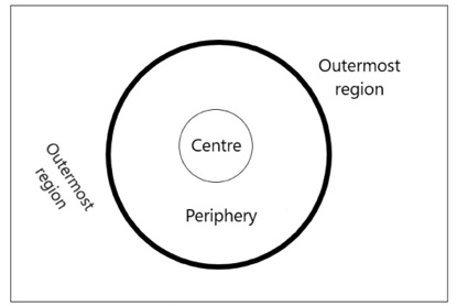
Source: own work.
We can therefore say that the Centre is the ‘commanding voice’ of the areas and, for this very reason, it can influence the forms of development of the regions under its influence. Thus, the central area (with political, economic, and social power) can determine the degree of periphery of the other territories.
Right after the area with decision-making power comes the periphery. This is identified by being beyond the limits of the Centre. Areas become more peripheral with distance from the centre, although this condition can vary with the degree of connectivity in terms of communications with it.
According to Hermet et. al. (2025), the concept of the outermost regions refers to an order of magnitude that is not very comparable in terms of distance. However, the outermost regions are both further away from peripheral areas and have spatial discontinuity. This is marked by a very significant morphological obstacle, such as the ocean (represented by the thickest boundary), which physically separates them from the periphery, thus making them very distant from the central area. In contrast, the outermost regions are spatially individualised, unlike, for example, the regions of mainland Europe, which, despite their administrative division, are connected at a terrestrial level (and, therefore, have spatial continuity). In fact, they are in an unfavourable geographical position, which has negative implications in terms of distance, time, and cost in relation to the periphery, and more especially to the Centre. The geographical factor of ‘ocean’ seems to us to be the aspect most relevant to having the spatial condition of being the outermost, and not so much the fact that they are islands, not least because the outermost regions in fact include a continental territory – French Guiana.
Consequently, outermost areas add a third pole to Friedman’s model (1966, 1972), but one which cannot be confused with the third component of the world system presented by Wallerstein (1974), the Semi-Periphery, since it is positioned between the Centre and the Periphery, while outermost regions are located beyond the limits of the periphery of the European Union.
Taking the ideas presented on the ‘outermost’ as a starting point, it was possible to develop a conceptual proposal for an outermost region (of the EuropeanUnion): a politically European region whose location is far from the European continent, separating it from respective decision-making centres and poles of national and community development.
3. Outermost Regions in the Treaties
Although the founding Treaty of the European Economic Community (Rome, 1957) made reference to the specific characteristics of the non-European regions of the French state, little progress was made in this direction until Portugal and Spain joined in 1986. It was the first enlargement of the EU to include three regions (Azores, Madeira, and Canary Islands) with similar characteristics and objectives. Thus, with the increase in the number of territories and Member States in the EEC/EU, there was a new force (and perhaps more will) to obtain specific support for this type of a region.
Ángel Fornieles Gil (2008) has indicated that this is not clear, P. Guillaumin (2004) and C. González Laínez (2005) stressed that the term ‘outermost’ was used for the first time in October 1987, at the General Assembly of the Conference of Peripheral and Maritime Regions (CPMR), on Reunion Island. It was used by Mota Amaral, the president of the Conference and of the Regional Government of the Azores then, when he tried to categorise the situation of the regions furthest from the European continent under the concept of ‘peripheral regions,’ spontaneously using the expression ‘more than’ and then ‘ultra’ (RUP PLUS, 2008; Valente, 2016).
It is no coincidence that the term ‘outermost regions’ appeared in 1987, according to Isabel Valente (2013, p. 116): “establishing the status of outermost regions for these areas is due to the unequivocal and enthusiastic action of the Regional Governments of Madeira and the Azores, in strict coordination with the Government of the Republic.” In this context, Amaral (2022), who as President of the Government of the Azores was directly involved in the process of recognising and consolidating the status of the outermost regions, had no doubts about attributing the leadership to Portugal. He noted in a Joint Declaration annexed to the Treaty of Accession in 1985 that he was considering the problems specific to the Portuguese Atlantic islands and the need to develop mechanisms capable of overcoming their structural disadvantages.
Isabel Valente (2013; 2016) emphasised the fact that in 1986, following a proposal by the President of the European Commission, Jacques Delors, an Inter-service group was formed to represent the Commission in its assignment to find specific measures for all non-European territories. According to this historian, it was this type of “Community approach that later brought together the four French Departments (Guadeloupe, Martinique, French Guiana and Réunion), the Canary Islands and the Autonomous Regions of the Azores and Madeira,” with a view to “upholding a common status that would allow the Community institutions to adopt specific measures for their territories,” (Valente, 2013, p. 119).
The first measures resulting from this approach began to be taken in 1989, when the programmes of specific options for dealing with remoteness and insularity, the POSEI, were approved. This was an exclusive support programme for regions a long way from mainland Europe. It set them apart within the European Economic Community by giving them one more Community programme than the other regions of the Member States. However, it was during the discussion of the first programme, POSEIDOM, in 1988 that Isabel Valente (2013; 2016) claimed that the outermost regions were born. This was when a working session was held on the island of Madeira, on the initiative of the President of the Regional Government of this archipelago, bringing together representatives of the regional governments of the seven outermost territories of the European Union, with the aim of addressing issues of common interest.
Although a certain awareness of the Outermost Regions had already been conceived, there was no legal or political recognition of them in the European Treaties. So the group of seven regions, backed by their countries, began to press for a common status in the Treaties. The first sign was given in 1992 with the signing of the Maastricht Treaty (or the Treaty of the European Union), in which the outermost regions were politically recognised in attached declaration no. 26. However, these distant territories were omitted from the body of the Treaty on European Union: this left clauses[3] in the primary law unchanged, and, therefore, it remained impossible to amend or change them through the legislative way to help Ors (Perrot, 2021). However, as a meeting was scheduled for 1996 with the main purpose of revising the Treaties, Danielle Perrot (2021) noted that the Presidents of the ORs took advantage of this meeting to reinforce their common position with the aim of removing from the texts what they considered to be obstacles to their development. This joint effort was successful because “in 1997 the Amsterdam Treaty introduced a legal basis for the outermost regions’ status,” (Oulahal, 2022, p. 129). Its body enshrined, for the first time in the history of the European Treaties, a common legal status for the outermost regions, through Article 299(2), a status that was consolidated in the most recent text of the European Treaties, the Treaty of Lisbon (2007), in which information on the outermost regions was included in Articles 349 and 355. This text states that in view of the structural social and economic situation of the outermost regions and the factors whose persistence and combination seriously jeopardise their development, the Council, on a proposal from the Commission and after consulting the European Parliament, would adopt specific measures aimed in particular at laying down the conditions of application of the Treaties to those regions, including common policies. When the specific measures in question were adopted by the Council in accordance with a special legislative procedure, the Council would also act on a proposal from the Commission and after consulting the European Parliament.
In fact, and although Alexandru Balas (2024) has stated that references to the ORs are still minimal in EU Treaties, there is no doubt that they are now categorically indicated in their texts. That is to say, the European Treaties recognise the structural handicaps of the ORs, as well as the need for specific measures tailored to the geographical reality of the region, to enable them to reach the average economic and social level of the European Union. Amaral (2022) considered that the struggle initiated by the Portuguese regions, even before Portugal joined the EEC, was successful, since when referring to the current text of Article 349 of the Lisbon Treaty, he stated:
One cannot fail to emphasise how the text of this provision draws its rationale from the ‘Declaration on the outermost regions of the Community’, annexed to the Maastricht Treaty, whose origins lie in the ‘Joint Declaration on the economic and social development of the autonomous regions of the Azores and Madeira’, annexed to the Treaty of Accession of Portugal and Spain to the European Communities (Amaral, 2022, p. 27).
4. Location of the Outermost Regions
The information in Article 349 of the Lisbon Treaty draws attention to an increase in the number of outermost regions, from the traditional seven to nine, but this does not coincide exactly with the current ORs. At first, in fact, there was an increase in the number of regions but not in territory. This is because Saint Martin and Saint Barthélemy were under the administration of Guadeloupe until 2007, when they voluntarily changed their status to a French overseas collectivity. Thus, once administratively separated from the archipelago of Guadeloupe, they acquired the status of outermost regions on 1 December 2009. Saint Barthélemy, however, by political will, shortly afterwards opted to move to the group of Overseas Countries and Territories (OCTs), which happened on 1 January 2012, and thus it left the group of outermost regions. In contrast, the island of Mayotte, took the opposite route. Traditionally classified as an OCT, in 2011 it obtained the status of a French overseas department which enabled it to join the group of the ORs on 1 January 2014 (Freitas, 2010).
In 2025, the European Union’s outermost regions comprised nine territories, all of them non-European, widely scattered across two oceans, the Atlantic and the Indian Ocean, and two continents, Africa and America (Fig. 2).
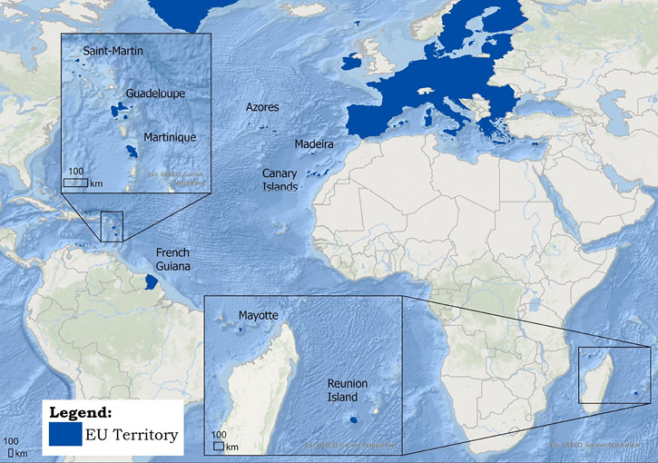
Source: own work, the map is based on Esri, GEBCO, Garmin, and NaturalVue.
Geographically, it is possible to identify four archipelagos: the Azores, Madeira, the Canaries, and Guadeloupe; one continental territory, French Guiana; three islands, i.e., Martinique, Réunion, and Mayotte; and, finally, a part of an island, i.e., Saint-Martin. The ORs thus have a predominantly insular profile, with one exception, i.e., French Guiana, which is a South American enclave in the Amazon rainforest. From a political point of view, these regions belong to three European Union Member States: Portugal (the autonomous regions of Azores and Madeira), Spain (the autonomous community of the Canary Islands), and France (one overseas collectivity, Saint-Martin, and five overseas departments, Guadeloupe, Martinique, Réunion, Mayotte, and French Guiana).
Table 1 provides information on the surface areas of the ORs, the actual physical distances to the capital of their country and the nearest continental territory.
| Regions/Islands | Surface (km²) | Distance to the capital of the country(km) | Minimum continental distance (km) | Nearest continental country |
|---|---|---|---|---|
| Azores | 2,333 | 1,448 | 1 448 (Europe) | Portugal |
| Canary Islands | 7,447 | 1,794 | 97 (Africa) | Morocco |
| Guadeloupe | 1,710 | 6,762 | 606 (America) | Venezuela |
| French Guiana | 84,000 | 7,228 | In America | Brazil and Suriname |
| Madeira | 795 | 969 | 638 (Africa) | Morocco |
| Martinique | 1,080 | 6,857 | 492 (America) | Venezuela |
| Reunion Island | 2,510 | 9,402 | 1 695 (Africa) | Mozambique |
| Saint Martin | 53 | 6,723 | 806 (America) | Venezuela |
| Mayotte | 376 | 8,053 | 493 (Africa) | Mozambique |
Source: own work based on Google Maps and National Geographic World Atlas.
The outermost regions vary considerably in size, from the 53 sq. km of Saint Martin to the 84,000 sq. km of the continental mass of French Guyana, an area similar to that of Portugal (92,000 sq. km). However, small island territories predominate, including inhabited spaces as small as the islands of Santos (12,8 sq. km) in Guadeloupe or the island of Corvo (17 sq. km) in the Azores, with the French territory of Réunion being the largest outermost island.
It is easy to conclude that the nine outermost regions are so far from the capitals of their countries that they are closer to a continent other than Europe. The only exception is the Azores archipelago, whose nearest continent is, in fact, Europe. However, in absolute terms, and in general, it is the most remote region, as the island of Réunion is 800 kilometres from Madagascar. Despite that, it is not the Azores, but Madeira, which is the least distant from the European continent, although it is closer to the African coast.
Considering the distance criterion, apart from the Azores, the other ORs are located on two other continents: Africa and America. French Guiana, as already mentioned, is a continental territory “embedded” in the Amazon rainforest and has land borders with Brazil and Suriname. The other regions are closer to three continental countries: Morocco (Madeira and the Canary Islands), Venezuela (the French Caribbean regions), and Mozambique (the French overseas departments in the Indian Ocean). These are continental areas with development problems, especially in the case of Africa, where the economic growth of the outermost regions leads to disparities with the surrounding region, which sometimes has consequences in terms of irregular migratory flows. It is on the basis of these circumstances that Portugués Carrillo and Zafra Díaz (2014) drew attention to the importance of characterising the ORs not only in terms of the fact that they were located a long way from Europe, but also in terms of their proximity to third countries.
From the above, there is no doubt that these are all regions that are located at very significant distances (spatially, temporally, and cost-wise) from the centre of Europe. This has a negative impact on their economic growth and human development, compared with the contiguous regions of Europe and the islands that are close to it, which creates permanent disadvantages with respect to achieving European cohesion.
Following this line of thinking, in 2002 an innovative proposal to virtually localise the outermost island regions existing at the time, which resulted from a study conducted by the interregional cooperation network EURISLES[4] (European Islands and Systems of Links and Exchanges) interregional cooperation network, was made on the initiative of the Islands Commission of the Conference of Maritime and Peripheral Regions of Europe (CPMR). This is a map that aims to represent the virtual distance of the outermost island regions from the centre of Europe, whose geographical precision is based on the symbolic city of Maastricht. To do this, the travelling time of a semi-trailer by road, the crossing time by ferry, and the respective frequency and waiting time coefficients were used. These times were then converted into kilometres, based on the average speed of 60 kilometres per hour of a lorry travelling on mainland roads. Once the conversion was done, the six outermost regions represented were significantly further away from their natural position. The island of Réunion, in the Indian Ocean, which is the furthest away in absolute terms, is less affected as most of its journey takes place on the African continent and not just on an ocean, as is the case with the other regions. Madeira and the Canary Islands are located in a position equivalent to the interior of Brazil (Amazon rainforest), the others are located in the Pacific Ocean, therefore, to the west of the American continent, with the French regions of Guadeloupe and Martinique being virtually the furthest from Maastricht.
At the time, this was undoubtedly very innovative and perhaps one of the most appropriate ways to represent the real dimension of the outermost regions, considering the fact that an ocean and/or a continent are responsible for the considerable increase in the real time-distance of European regions, which are very far away from the continent to which they politically belong.
5. Socio-economic framework of the Outermost Regions
The nine outermost regions together are home to more than 5 million inhabitants, with the Canary Islands standing out with more than 2 million residents (Table 2). Saint Martin has the fewest residents, numbering just over 32,000. Most of these regions have high densities, with the exception of the Azores (104 inhabitants per square kilometre) and French Guiana (3 inhabitants per square kilometre), the others range from 241 inhabitants per square kilometre in Guadeloupe to 742 inhabitants per square kilometre in Mayotte.
| Region | Population (2020) | Fertility índex (2019) | GDP PPC per average inhabitant of EU (2020) | General unemployment rate % (2020) | Poverty risk rate % (2021) | Number of doctors per 100,000 inhabitants (2019) | Early drop-out of studies: % between 18 and 24 years old (2023) | Population with 24 years old with complete higher education % (2020) | % of households with broadband Internet access (2021) |
|---|---|---|---|---|---|---|---|---|---|
| European Union (27) | 447.3 million | 1.53 | 100 | 7.1 | 16.5 | 391.0 | 9.9 | 32.8 | 88 |
| France | 67.3 million | 1.83 | 104 | 8.1 | 15.6 | 336.4 | 8.0 | 39.7 | 88 |
| Guadeloupe | 412,682 | 2.30 | 69 | 17.5 | 31.3 | 277.9 | 22.3 | 23.3 | 75 |
| French Guiana | 288,086 | 3.73 | 46 | 16.1 | 42.0 | 219.2 | 33.6 | 18.7 | 79 |
| Martinique | 359,821 | 2.00 | 76 | 12.4 | 26.0 | 305.9 | 18.5 | 27.1 | 86 |
| Mayotte | 278,926 | 4.60 | 30 | 27.8 | – | 81.0 | – | – | – |
| Reunion Island | 856,858 | 2.39 | 68 | 17.4 | 34.5 | 337.6 | 24.7 | 22.9 | 87 |
| Saint Martin | 32,489 | – | – | – | – | – | – | – | – |
| Portugal | 10.3 million | 1.43 | 76 | 6.9 | 16.4 | 532.2 | 9.1 | 28.2 | 84 |
| Azores | 242,786 | 1.24 | 67 | 6.1 | 25.1 | 354.5 | 27.0 | 15.8 | 88 |
| Madeira | 254,254 | 1.16 | 69 | 8.1 | 25.9 | 442.3 | – | 22.9 | 87 |
| Spain | 47.3 million | 1.23 | 84 | 15.5 | 20.4 | 440.4 | 16.0 | 39.7 | 96 |
| Canary Islands | 2.2 million | 0.94 | 62 | 22.6 | 29.4 | 394.5 | 18.2 | 34.4 | 97 |
Source: European Commission (2022, pp. 3−4).
The French ORs have high synthetic fertility rates, indicative of their demographic vitality, which can be double the national average, as in the cases of French Guiana and Mayotte. The Portuguese regions, and Spain, in particular, have very low figures, unable to ensure the renewal of generations, and even lower than the results for their own countries. This type of demographic contrast had already been observed by Frank Temporal (2015), who especially highlighted the extremely young population of these French regions. It should also be noted that despite the weak demographic performance of the Iberian regions, they are still among the youngest at national level as a result of the general ageing of the Iberian populations.
In 2020, all the outermost territories had a GDP per capita that was far from that of the European Union and below the average results achieved by their respective countries. Despite these differences, Tiago Freitas (2010) initially noted that since 1995 most ORs have had grown faster than the EU27 average, emphasising the rapid growth of Madeira and identifying French Guiana as the only deviating region. However, the European Union Communication (2022) showed that between 2000 and 2020 only Réunion, Mayotte, and Martinique managed to come close to the EU average, with Guadeloupe achieving zero growth and the other regions falling further behind. Bourdin et al. (2024) stressed the divergence observed over the last decade, even questioning the effectiveness of recovery policies for the ORs. These authors have noted that the COVID-19 crisis will have affected the outermost regions more, but we cannot ignore the serious international financial crisis of 2008, which shook the economies of southern European countries, strongly affecting the results of the Portuguese archipelagos and the Canary Islands.
In 2020, Mayotte and French Guiana stood out because they were more than 50% below the EU average, revealing how far behind they were in terms of development, while Martinique had the highest figure, identical to that achieved by Portugal (76%). Fontaine and Hermet (2025) ascribed Mayotte’s significant lag to the persistence of a subsistence economy, still largely based on traditional principles, particularly on agriculture, fishing, crafts and livestock farming. With regard to French Guiana, Silva et al. (2016) indicated that the economic lag stemmed from its distance from France and its links with economically fragile countries, implying a high dependence on national funds and the weak development of its economic sector, which was mainly based on the exploitation of natural resources. Meanwhile, the European Commission Communication (2022) emphasised that the standard of living of Martinique’s residents was one of the highest in the Caribbean, with a thriving agricultural sector in banana and rum production and significant tourism activity.
Overall unemployment rates are higher in the ORs, with the exception of the Azores, which has the lowest percentage overall. People’s risk of poverty is also considerably higher in the ORs: in 2021 they had a much higher risk of poverty rates than the national and EU figures. As a result, no OR had a figure lower than 25.1% (Azores), while no national average exceeds 20.4% (Spain). The Portuguese ORs had the lowest at-risk-of-poverty rates, while the highest percentages generally corresponded to the French territories, with French Guiana having the highest rate, at around 42%.
In terms of access to healthcare, the ORs were in a worse position in terms of the number of doctors per 100,000 inhabitants in 2019 compared with the average figure for their countries, apart from Réunion, which managed to slightly outperform France. Mayotte’s low figure was a cause for concern, as it greatly limited its population’s access to specialised healthcare.
In terms of education, on the one hand, school dropout rates between the ages of 18 and 24 were much higher in the ORs compared to the average for the countries and the European Union, although the imbalance was not considerable in the case of Spain because the national figure was also high. On the other, in terms of the percentage of the population with completed higher education, the Canary Islands were notable for having a figure higher than the European Union average, while the Azores were in the opposite situation, with only 15.8%. All the ORs had a percentage of inhabitants with completed higher education that was lower than the national figure.
In terms of the percentage of households with broadband internet access in 2021, the outermost regions of Portugal and Spain had higher coverage than the national figure, with the Canary Islands having close to 100 per cent. With no data for Saint Martin and Mayotte, no OR had coverage of less than 75 per cent, while Réunion and Martinique had percentages close to that of France. Considering this indicator, there was a real convergence with the EU standard, since most of the ORs were not that far from the EU average, and even exceeded it in the case of the Canaries.
Despite this kind of approximation to the European average values, it is undeniable that, considering most of the indicators presented, “the ORs are in fact still significantly behind in their development compared to the EU average” (Bourdin et al., 2024, p. 583). In contrast, these authors claim that the outermost regions are “islands of prosperity” in their regional environments. In fact, apart from the Portuguese regions, and especially the Azores, the other ORs are located in regions of weak economic and social development, given their location in the Caribbean/South America and close to the African continent. It is, therefore, not surprising that Frank Temporal (2015) characterised the Canary Islands as a foreign immigration area. However, he did the same for French Guiana and Mayotte, even though these are generally the ORs that lag furthest behind in development, which may indicate a poorer type of neighbourhood and/or easier access for immigrants than are found in other outermost regions.
Conversely, according to Nascimento and Valente (2024) there is currently a new epistemological concept for the ORs in that they are beginning to be valued as assets and opportunities for the EU, as an alternative to a perspective that is overly focused on the concept of problem regions. In this sense, Balas (2024) has warned that references to ORs in EU treaties focus only on socio-economic development issues, making no direct reference to the geopolitical potential of these regions. What is really at stake is the possibility for the EU to further exploit the advantages related to the geostrategic position of the ORs in various areas of the globe (Valente, 2015; Freitas, 2022; Fonseca, 2023; Balas, 2024; Nascimento and Valente, 2024). The potential is indeed enormous, giving the EU a global dimension and greatly increasing its maritime representation. The ORs constitute European platforms in other parts of the globe, with the capacity to develop various types of cooperation with the African and American continents and even influence the transmission of European values in more problematic neighbouring areas.
6. Measures in the context of the status of the Outermost Regions
The persistence in recognising the status of outermost regions and their subsequent inclusion in the texts of the European Union Treaties was based on the idea of providing these regions with special mechanisms that were sufficiently capable of counteracting the enormous structural handicaps that these regions faced on a permanent basis. Constraints that might, for example, be the regions of fragmented archipelagos, since they consist of a considerable number of inhabited islands, across which the population is spread. This characteristic could naturally indicate development difficulties. On the one hand, a small surface area means little agricultural land available and a shortage of raw materials. In addition, the degree of morphological homogeneity of the areas could have implications in terms of less climatic diversity. This would affect the agricultural sector, causing economic dependence on a small number of products and the need to import most of the goods consumed. On the other, the low number of inhabitants is a sign of a weak consumer market which, when the region is very fragmented, reduces the chances of economies of scale being developed. However, these circumstances could be minimised, and even enhanced, if there were, in fact, greater economic integration in the immediate area, benefiting from being part of a dual geo-economic space − the European Union and the surrounding geographical region.
Aragón and Hernández Arteaga (2022) have noted that the legal regime for the outermost regions includes not only direct support measures through the European Union budget, but also the possibility for their countries to justify changes to part of the legal regimes established at EU level, such as tax or competition law. With regard to support measures, Isabel Valente (2009) grouped them into two categories: special economic and fiscal measures, with a direct taxation regime, distinct from the rest of the EU on the one hand and specific supply regimes, with price subsidy mechanisms for certain consumer goods on the other. Most of these measures are part of the programmes of options specific to remoteness and insularity (POSEI), created specifically for the outermost regions. However, support for the ORs is not limited to this type of programme, and they are granted special benefits in other programmes with a global scope.
During the 2014−2020 period, the ORs benefited from a total EU investment of €13.3 billion (Lopes, 2022), which represents an increase of approximately one billion euros compared to the previous period (2007–2013).
| Regions/ Countries (€ million) |
ERDF | ERFF+ | ESF | ESF+ | EAFRD | EMFAF | REACT-EU | POSEI | By Country and Grand Total |
|---|---|---|---|---|---|---|---|---|---|
| Guadeloupe | 465 | 94 | 199 | 27.5 | 155 | brak danych | 195 | brak danych | brak danych |
| French Guiana | 346 | 65 | 165 | 22.4 | 97 | brak danych | 165 | brak danych | brak danych |
| Martinique | 393 | 89 | 164 | 27.7 | 112 | brak danych | 198 | brak danych | brak danych |
| Mayotte | 389 | 58 | 122 | 16.5 | 53 | brak danych | 139 | brak danych | brak danych |
| Reunion Island | 1033 | 203 | 443 | 61 | 337 | brak danych | 489 | brak danych | brak danych |
| Saint Martin | 51 | 8 | 17 | 2.4 | brak danych | brak danych | 43 | brak danych | brak danych |
| France | 2677 | 517 | 1110 | 158 | 754 | 142 | 1229 | 1949 | 853.5 |
| Azores | 632 | 58 | 431 | 19 | 285 | brak danych | 128 | brak danych | brak danych |
| Madeira | 400 | 60 | 280 | 20 | 173 | brak danych | 86 | brak danych | brak danych |
| Portugal | 1032 | 118 | 711 | 39 | 458 | 102 | 214 | 743 | 3417 |
| Canary Islands | 1430 | 507 | 682 | 166 | 148 | 88 | 630 | 1879 | 5530 |
| Total Programs | 5139 | 1142 | 2503 | 362.5 | 1360 | 332 | 2073 | 4571 | 17482.5 |
Source: European Commission (2022).
Based on the information available in the European Union document Overview of the outermost regions – assets, challenges and opportunities (2022)[6], whose sources of funding for the ORs are shown in Table 3, we can conclude that for the 2021−2027 period there has been an increase in the specific additional allocation of around €1.514 billion. This comprises €1.142 billion for the Structural Funds (ERDF) and €372 million for the European Social Fund Plus (ESF+). For the allocation of the additional ERDF funds, the outermost regions are considered less developed, regardless of their GDP, and are exempt from the requirements for the allocation of thematic concentration. Furthermore, the ORs can use these funds to make investments in certain areas that are not authorised in the other regions of the European Union: “with the exception of the outermost regions, cohesion policy no longer supports the construction of airport infrastructure” (Aragón and Hernández Arteaga, 2022, p. 44). The new specific ESF+ allocation is also released from the allocation of this fund by thematic areas and is intended to promote youth employment and education and training in the ORs. POSEI is still allocated €635 million euros a year, distributed as follows: €278.4 million for the French regions, €106.2 million for the Portuguese territories, and €268.4 million for the Canary Islands. This type of funding is aimed at supplying essential farming products and supporting local agricultural production. Nor are there any changes to the volume of funding made available under the European Maritime, Fisheries and Aquaculture Fund (EMFAF), with €315 million earmarked for compensation for additional costs and for structural investments. The ORs are able to allocate 60% to compensation, in which case they will receive the full amount from the EU. The European Agricultural Fund for Rural Development (EAFRD), worth €1360 million euros, provides 85% co-financing for the least developed outermost regions and 80% for the others, adds the highest sectoral co-financing rates and offers exemptions from various obligations, which helps to simplify access to the funds for the ORs. The Recovery Assistance Programme for Cohesion and the Territories of Europe (REACT-EU) foresees a specific additional amount of €146.4 million, on top of the national allocations, which will generate a total investment of €2,000 million. €280 million is also available for cooperation between the ORs and other neighbouring territories, including a co-financing rate for cooperation projects in the outermost regions (Interreg). The Connecting Europe Facility (CEF) has specific provisions to support projects in the ORs’ transport, energy and digital sectors, with co-financing rates of 70%. Investments in connections to ports and airports and urban nodes can be co-financed.
The programmes presented and the support measures for the ORs mentioned are currently the most significant, although there are many more in various EU programmes. These can be consulted, for example, in the European Commission staff working document (2022.5.3).
Between 2021 and 2027, an overall investment of €17.483 billion is planned for the nine outermost regions as a whole. Combining more favourable co-financing rates with additional specific appropriations, and also benefiting from an exclusive programme worth a total of €4.571 billion, the inhabitants of the outermost regions represent the largest investment in the European Union: “the existence of the outermost regions requires the EU to step up its efforts towards economic, social and territorial cohesion” (Aragón and Hernández Arteaga, 2022, p. 41). Arthur Olivier (2025) reinforces this idea by stating that the ORs are the regions of the European Union that benefit most from Cohesion Policy and gives the French ORs as an example, since they represent only 3.2 per cent of France’s population but account for 17.4 per cent of the structural funds received at national level.
7. Conclusion
Some of the founding countries of the EEC/EU have had extra-European territories since the Treaty of Rome. However, there is no doubt that it was with the entry of the Iberian countries, almost thirty years later, that the idea of them benefiting from their own status within the European Union gained momentum. The term ‘outermost region’ emerged and was politically accepted, while at the same time a specific support programme was created for these territories, i.e., POSEI. It was in a declaration annexed to the Maastricht Treaty that the outermost regions first appeared at this level, and they were later consolidated in the Amsterdam and Lisbon Treaties, evolving to form “a category of their own, distinct from that of the other Community territories,” (Asín Cabrera, 2005, p. 9).
The main scientific contribution of this article is to present a proposal for the concept of the outermost region and its original conceptual schema (Fig. 1). The concept of outermost regions is defined in terms of their great distance from the “European centre” and their territorially discontinuous nature, interrupted by an ocean and/or other continents. The recognition of the enormous structural difficulties of the outermost regions in the European Treaties has led to the creation of more advantageous mechanisms for these regions, making this the most positive discrimination in the whole of the European Union. In fact, over the last thirty years there has been a significant channelling of Community funds, with obvious impacts on the outermost regions at various levels, but especially in the economic and social spheres. Despite the huge Community investment made and the progress that has been achieved, the development indicators of the outermost regions are still generally below those of their countries, and far from the average for the European Union. This is why the largest ever increase in support for this type of territory for the 2021−2027 period is justified. It invokes the European Union’s principle of solidarity with regions with very specific geographical constraints.
The fact that we have presented a simple research methodology and that the statistical data used is somewhat limited is mainly down to two fundamental reasons: first, our intention was to only provide an introduction to the characterisation of the various ORs, and second, the necessary statistical information is not always available for the different outermost regions. Emphasising this difficulty, Sébastian Bourdin et al. (2024) have even indicated that the ORs are often overlooked in the EU’s spatial approach in academic studies due to the unavailability of statistical data. In this context, the almost complete absence of official data on Saint Martin, as well as the lack of certain statistical information on Mayotte, naturally affected the interpretation of the results, since the planned socio-economic characterisation was substantially incomplete, making it difficult to compare them with the other regions. The small amount of data available for Mayotte indicates that it is the least developed OR, but it has not been possible to determine the actual degree of development of Saint Martin.
Nevertheless, progress has been made in terms of providing information on these territories, which will surely help to consolidate other lines of research. In this context, we believe that the conditions could be met for studies to be carried out in the ORs on more specific themes, such as those suggested below: migration: origins, causes and types; European vs non-European tourism: internal and external transport networks; trade relations in goods and services with the European Union.
Acknowledgments. We express our gratitude to Claudia Costa for her contribution to the preparation of the map in Figure 2.
Funds. This research received support from the Centre of Studies in Geography and Spatial Planning (CEGOT), funded by national funds through the Foundation for Science and Technology (FCT) under the reference UIDB/04084/2020.
Autorzy
References
ABAMUKONG, B. and JOBST, S. (2016), ‘The Social Capital Theory in the Light of a Centre-Periphery Comparison’, International Dialogues on Education, 3 (1), pp. 36−51. https://doi.org/10.53308/ide.v3i1.174
Alberto, D. (2009), ‘Regional Development and Competitiveness: Application of the Triple Helix Model to NUT III Beira Interior Sul’, University of Beira Interior, Covilhã, January 2009, http://hdl.handle.net/10400.11/757 [accessed on: 30.04.2024].
AMARAL, J. B. M. (2022), ‘The creation of the concept of European outermost regions – a fight for human rights!’, [in:] VALENTE, I. M. F. (ed.), Atlantic outermost regions: bridge(es) between the EU and the USA, Editora Mente Aberta, pp. 131−165, https://estudogeral.uc.pt/bitstream/10316/112424/1/EUROATLANTICO%2016_E-book%20final.pdf [accessed on: 12.11.2024].
ARAGÓN, A. and HERNÁNDEZ ARTEGA, G. M. (2022), ‘The creation of the concept of European outermost regions – a fight for human rights!’, [in:] VALENTE, I. M. F. (ed.), Atlantic outermost regions: bridge(es) between the EU and the USA, Editora Mente Aberta, pp. 39−56, https://estudogeral.uc.pt/bitstream/10316/112424/1/EUROATLANTICO%2016_E-book%20final.pdf [accessed on: 12.11.2024].
ASÍN CABRERA, M. A. (2005), ‘La constitución europea y el estatuto jurídico de las regiones ultraperiféricas’, Hacieenda Canaria, 12 (2), pp. 5−23, https://www3.gobiernodecanarias.org/tributos/atc/estatico/info_tributaria/revista/Revista12/RevistaHC_12_1.pdf [accessed on: 07.10.2024].
BALAS, A. (2024), ‘European Union’s Use of the Outermost Regions (Ors) and the Overseas Countries and Territories (OCTs) to Promote Its Geopolitical Interests in the Atlantic, Caribbean, Indian, and Pacific Regions’, [in:] LIKA, L. and RIGA, D. (eds), EU Geopolitical Actorness in a Changing World, London: Palgrave Macmillan, pp. 217−241. https://doi.org/10.1007/978-3-031-81160-9
BOURDIN, S., HERMET, F. and JEAN-PIERRE, P. (2024), ’Les regions ultrapériphérique de L`Union européenne son-elles toujours en retard de development’, Revue Économique, 75 (3), pp. 579−599. http://dx.doi.org/10.3917/reco.753.0579
EURISLES (2002), Off the coast of Europe. European construction and the problem of the islands, CPMR – Islands Commission. https://europeansmallislands.com/wp-content/uploads/2016/04/off-the-coast-of-europe.pdf [accessed on: 14.11.2024].
EUROPEAN COMMISSION (2022), Overview of the outermost regions – assets, challenges and opportunities, COM 198 final, https://ec.europa.eu/regional_policy/sources/policy/themes/outermost-regions/rup-2022/comm-rup-2022-glance_en.pdf [accessed on: 02.05.2025].
FONSECA, H. (2023), ‘The Outermost Regions and the Europe Union’s presence in the World’, Debater a Europa, 26/27, pp. 183−193. https://doi.org/10.14195/1647-6336_26/27_9
FONTAINE, I. and HERMET, F. (2025), ‘L‘évolution du niveau de développement à Mayotte: Une mesure à partir de données satellitaires de luminosité nocture’, Revue d’Économique Régionale & Urbaine, 2025/2, pp. 255−278. http://dx.doi.org/10.3917/reru.252.0255
FORNIELES GIL, A. (2008), ‘El principio de proporcionalidad y la fiscalidad de las regiones ultraperiférica’, Hacieenda Canaria, 22 (1), pp. 235−273, https://www3.gobiernodecanarias.org/tributos/atc/estatico/info_tributaria/revista/Revista22/RevistaHC-22_13.pdf [accessed on: 12.10.2024].
FREITAS, T. (2010), ‘Development of the EU’s Outermost Regions’, Library of the European Parliment, 092, pp. 1−8, https://www.academia.edu/3825218/Development_of_EUs_Outermost_Regions [accessed on: 18.04.2025].
FRIEDMAN, J. (1966), Regional Development Policy: a case study of Venezuela, New York: MIT Press.
FRIEDMAN, J. (1972), ‘General Theory of Polarised Development’, [in:] HANSEN, N. (ed.), Growth Centres in Regional Economic Development, New York: Free Press, pp. 82−107.
HERMET, F., HOARAU, J. P. and LACOUR, C. (2025), ‘Introduction – Periphericity and ultraperiphericity in the context of major crises: distance is coming back’, Revue d´Économie Régionale & Urbaine, 2025/2, pp. 167−182, http://dx.doi.org/10.3917/reru.252.0167
LIBERATO, R. (2008), ‘Revisiting the models and theories of regional analysis’, Caderno de Geografia, 18 (29), pp. 127−136.
LOPES, N. S. (2022), ‘The status of Outermost Region and its importance for the EuropeanUnion: the Azorean case’, Portuguese Journal of Political Science, 18, pp. 105−120. https://doi.org/10.59071/2795-4765.RPCP2022.18/pp.105-120
NASCIMENTO, E. and VALENTE, I. (2024), ‘Outermost regions of the European Union (ORs)’, [in:] VALENTE, I. (ed.), The Insular dimension of Europe and the islands in the European Union: heteronomy, autonomy and sub-sovereignt, EURILHAS, pp. 75−81. https://doi.org/10.29327/5402055
OLIVIER, A. (2025), ‘Les régions ultrapérifiques, territoires européens au coeur des océans’, Toute l´europe: comprende L´Europe, https://www.touteleurope.eu/l-europe-en-region/les-regions-ultraperipheriques-territoires-europeens-au-coeur-des-oceans/ [accessed on: 02.05.2025].
OULAHAL, R. (2022), ‘Education in the French Outermost Regions: Interculturation as a basis for a necessary work of memory?’, Revista Lusófona de Educação, 55, pp. 127−137. https://doi.org/10.24140/issn.1645-7250.rle55.08
PERROT, D. (2021), ‘Insularity and Law: Diversity and Changeability of Islands`Statuses – The Example of French Outermost Regions in French and EU Law Systems’, Liverpool Law Review, 42, pp. 71−85. https://doi.org/10.1007/s10991-020-09263-y
PORTUGUÉS CARRILLO, C. and ZAFRA DÍAZ, J. (2014), ‘La actualización del marco normativo europeo específico para la ultraperiferia’, [in:] CABRERA, M. A. and GODENAU, D. (eds), Movilidad y Gran Vencidad en las Regiones Ultraperiféricas de la Unión Europea, Santa Cruz de Tenerife: Cabildo Insular de Tenerife, pp. 17−38.
RUP PLUS (2008), Co-operation between the outermost regions: The regional framework operation. European Commission – Regional Policy, https://www.cp-omr.eu/pt/wp-content/uploads/2011/10/A-coopera%C3%A7%C3%A3o-entre-as-Regi%C3%B5es-Ultraperif%C3%A9ricas-A-Opera%C3%A7%C3%A3o-Quadro-Regional-RUP-plus-PT.pdf [accessed on: 13.11.2024].
SILVA, G. V., PORTO, J., SANTOS, P. and DHENIN, M. (2016), ‘La géopolitique de l´‘Union Européenne por les régions ultrapériphérique: Assimilation, fragmentation et rôle de la Guyane française dasn son contexte régional’, Confins, 26, pp. 1−19. http://dx.doi.org/10.4000/confins.10658
TEMPORAL, F. (2015), ‘Les régions ultrapériphériques’, L´Éurope en formation, 377 (3), pp. 61−78. http://dx.doi.org/10.3917/eufor.377.0061
VALENTE, I. (2009), ‘The Portuguese outermost regions: political discourse and the regional press’, Revista Mneme, 10 (26), pp. 39−57. https://periodicos.ufrn.br/mneme/article/view/7 [accessed on: 10.11.2024].
VALENTE, I. (2013), ‘The Construction of a Concept – Outermost Region’, Revista Debater Europa, 8, pp. 111−151. https://www.academia.edu/6859093/A_Constru%C3%A7%C3%A3o_de_um_conceito_Regi%C3%A3o_Ultraperif%C3%A9rica [accessed on: 10.11.2024].
Valente, I. (2015), ‘The Atlantic outermost regions, the furthest frontiers of Europe’, Debater e Europa, 12, pp. 75−84. https://doi.org/10.14195/1647-6336_12_4
VALENTE, I. (2016), ‘Portugal, regional policy and the outermost regions’, Revista Debater a Europa, 15, pp. 175−196. https://doi.org/10.14195/1647-6336_15_10
WALLERSTEIN, I. (1974), ‘The rise and fall of the world Capitalist System: Concepts for Comparative Analysis’, Comparative Studies in Society and History, 16 (4), pp. 387−415. https://doi.org/10.1017/S0010417500007520
FOOTNOTES
- 1 Until 2020, when the United Kingdom left the European Union.
- 2 “...but rather have an association agreement with the EU” (Balas, 2024, p. 219).
- 3 There are rules in the text of the Treaties that are so precise that not even the Council or the Member States can infringe or circumvent them. The designated clauses thus constitute what are known as clauses preventing differentiation (Perrot, 2021).
- 4 It can be consulted in EURISLES (2022, pp. 69−70), https://europeansmallislands.com/wp-content/uploads/2016/04/off-the-coast-of-europe.pdf
- 5 Note that no information is available for Saint Martin other than the resident population. Therefore, the remaining analysis does not include this French territory. The same applies to Mayotte for some indicators.
- 6 Accompanying the Communication from the Commission to the European Parliament, the Council, the European Economic and Social Committee and the Committee of the Regions. It can be consulted at this link: https://ec.europa.eu/regional_policy/sources/policy/themes/outermost-regions/rup-2022/comm-rup-2022-glance_en.pdf