Volume 30, 2023, Number 2
https://doi.org/10.18778/1231-1952.30.2.03


Abstract. With more than 50 percent of the global population living in urban areas, Sustainable Development Goal 11 on Sustainable Cities and Communities provides a critical lever for us to realise all other SDG goals. This calls for tracking urban spatial development at various levels to facilitate a better understanding of the role, amongst others, of remote sensing data in the field of sustainable urban development and services of general interest to be provided by authorities. Urbanisation patterns may thus be retraced, but also modelled in order to provide evidence for decision makers. Without proper planning, the spatial impacts of urbanisation and subsequent spatial inequalities are more likely to affect disadvantaged groups most. In the last decade of the SDGs, the use of data to inform policies is very critical, and such evidence needs to be anchored in multi-level analysis and ensure vertical and horizontal applications at all governance levels.
Key words: sustainable development, 2030 Agenda, Sustainable Development Goals (SDGs), sustainable cities and communities, land-use, built-up area, services of general interest, remote sensing data.
With a majority share of the global population increasingly living in urban areas, meeting the parameters of SDG 11 should be viewed as critical for achieving the 2030 Agenda’s vision of global development. Cities and human settlements are the locus of opportunity to accelerate progress achievement of all the Sustainable Development Goals and climate change aspirations. Delivering on each of these areas will increasingly be determined by how well we plan and manage our cities and human settlements, the effectiveness of local action, and responses to emerging challenges and opportunities.
The 2030 agenda for Sustainable Development which was unanimously adopted by all member states in 2015 is a commitment by all countries and stakeholders to work towards implementing actions that ensure that no place and no one is left behind (United Nations, 2015). While all the goals within the Sustainable Development Goals (SDGs) framework envision actions around the 5 main areas of people, prosperity, planet, peace, and partnerships where interventions are needed to attain sustainability, each of the actions target a unit of implementation, both in the geographic and the man-made environment. The agenda, and its monitoring framework also recognises that actions in one area affects outcomes in other areas, both in scale and focus of operation, and thus call for balanced territorial development that must consider the social, economic, and environmental elements of sustainability (United Nations, 2015).
In addition, approximately one-third of the SDG indicators require monitoring at the local level (United Nations, 2018), which also includes indicators that form the ‘urban’ goal – SDG 11: Sustainable Cities and Human Settlements. SDG 11 presents a very specific scenario where the unit of analysis for most targets is – the city/urban area, with aggregation of results done to the national, regional, and global levels. Specifically, Goal 11 does require city/urban specific analyses, while also integrating key aspects of spatial analysis – from the overall relation of all targets and indicators to a spatial unit, to demands for use of earth observation and geospatial data for the individual cities/localities. In addition, SDG 11 focuses on the urban domain of sustainable development, and acknowledges the interlinkages between the natural and living environments and the fact that sustainability requires a more holistic analysis of trends and implementation of actions – which must encompass the urban, rural, and other types of settlements, as well as other areas of the living and geographic/natural environments.
Empirical data shows that small cities cover almost half of city land (about 45 percent) in low-income countries, a trend that will persist over the coming decades (UN-HABITAT, 2022b). Fast-paced urban growth in lower income contexts coupled with limited public response capacities, especially in smaller urban areas, risks an outcome of unplanned urbanisation rather than producing sustainable cities and human settlements at the global scale. Therefore, unless we invest more in understanding urbanisation trends at all levels and scales, greater divergence in the quality of urbanisation between cities in developed and less developed regions and within countries may emerge, with a higher potential of expounding broader global inequality.
As prescribed in the SDG framework’s targets, and later reinforced by the New Urban Agenda, the attainment of the globally agreed vision is only possible if actions are implemented at multiple scales – from micro to meso and macro levels. To attain the principle of leaving no one behind, we require a series of activities, ranging from ensuring a consistent way of measuring and understanding inequalities that can be applied uniformly by all countries (such as those proposed through SDG monitoring framework), to implementing specific actions at the meso (national/regional) and micro (city, settlement, and neighbourhood) levels.
The New Urban Agenda and the 2030 agenda for sustainable development spell out different levels of action and engagement, the most visible ones being the global, regional, national, and local levels. Paragraphs 3 to 5 of the United Nations General Assembly Resolution 70/1 which established the 2030 Agenda highlights (United Nations 2015: 3/35) “the sub-national, national, regional and global levels where interventions are needed to ensure we achieve our shared future.” Specifically member states committed to:
“3. We resolve, between now and 2030, to end poverty and hunger everywhere; to combat inequalities within and among countries; (…) We resolve also to create conditions for sustainable, inclusive and sustained economic growth, shared prosperity and decent work for all, taking into account different levels of national development and capacities.
4. As we embark on this great collective journey, we pledge that no one will be left behind. Recognizing that the dignity of the human person is fundamental, we wish to see the Goals and targets met for all nations and peoples and for all segments of society. And we will endeavour to reach the furthest behind first.
5. This is an Agenda of unprecedented scope and significance. It is accepted by all countries and is applicable to all, taking into account different national realities, capacities and levels of development and respecting national policies and priorities. These are universal goals and targets which involve the entire world, developed and developing countries alike. They are integrated and indivisible and balance the three dimensions of sustainable development.”
While projecting the commitment by member states and the global community at large, the targets outlined in each of the SDGs are to be achieved at a more localised level, such as cities, neighbourhoods, villages, certain ecosystems, or other units. For example, to achieve sustainable cities and human settlements (SDG 11), a series of actions are required at the urban level, such as those aimed at ensuring every urban resident lives in a decent house and has access to all basic services. To realise this ambition, specific interventions are needed in all the neighbourhoods within the city. The SDG framework also highlights very localised intervention areas, such as in target 16.1 (reduce violence and related deaths everywhere) where safety should be enhanced at the neighbourhood level. Target 9.1 requires specific actions aimed at enhancing rural connectivity and access to opportunities and services among rural populations by ensuring everyone is within 2 kilometres of an all-weather road. Tracking access to services or opportunities in such rural communities requires analysis that covers individual villages and aggregating such analysis to the national level.
The local, sub-national, national, regional and global level analysis is further emphasised in the SDG monitoring framework (United Nations, 2017), which provides that “Sustainable Development Goal indicators should be disaggregated, where relevant, by income, sex, age, race, ethnicity, migratory status, disability and geographic location, or other characteristics, in accordance with the Fundamental Principles of Official Statistics.” The city/urban area is one of the major ‘geographic locations’ for which SDG indicators should be disaggregated.
The case for multi-level analysis of urban and spatial development is thus deeply entrenched in the 2030 Agenda for sustainable development and more so for SDG 11 targets. Recognising the role that cities and urban areas play in the attainment of sustainable development is a great starting point, and this is further emphasized by the New Urban Agenda (United Nations, 2017b) which complements the need for analysis of urban and spatial development across different scales and specifically for all the five pillars of the New Urban Agenda outlined as National urban policies, rules and regulations, urban planning and design, financing urbanisation, and local implementation.
In this article, we highlight the relevance of multi-level analysis in shaping policies and actions towards sustainable development, with a specific focus on interventions that target urban areas. We acknowledge that the attainment of sustainable development is not limited to interventions only in the urban areas which this article focuses on, but rather multi-level actions must be undertaken in all types of settlements (urban, peri-urban, and rural), as well as for other geographies/natural environments as prescribed by the SDG framework.
Our rapidly urbanising world requires continuous monitoring of urban transformations both, in time and space, and constantly ensuring that we use the resulting knowledge to inform new policies and actions to advance progress towards sustainable urbanisation at the regional and global levels. Urbanisation manifests itself both spatially and demographically, and at multi-level scales ranging from the neighbourhood to the city, national, and global. The rate at which the demographic and spatial trends change at the different scales requires continuous monitoring through well-established monitoring systems that start at the local level (UN-HABITAT, 2018). For example, many datasets that showcase global urbanisation trends – such as the world urbanisation prospects and Global Human Settlements Layer (GHSL) – are based on data/estimates produced at the individual city level, which then gets aggregated to national, regional and global levels (Florczyk et al., 2019). Production of data at the individual city level is often costly, especially in cases where surveys have to be implemented. Equally, the availability of comparable data relies on methodological alignments, both in terms of defining the spatial ‘city/urban’ unit and also the method used to produce the data. Due to recent developments in technology, alongside availability of open and free data, and methodological alignments, traditional challenges that hindered the understanding of our urban and spatial shifts through data are increasingly an issue of the past, making it possible to continuously produce and update policy-relevant data from the local to global scales (UN-HABITAT, 2023).
A major achievement over the last few decades that has enhanced availability of multi-level data across countries has been enhancements in space applications and related analytics, which today make it possible to analyse urbanisation trends at an ever growing spatial and temporal resolution. For example, the availability of free and open-source satellite imagery from the Landsat and Sentinel missions, coupled with openly accessible processing technologies such as Google Earth Engine, has made it possible to assess urban changes for the whole globe at sub-annual scales (UN-HABITAT, 2023). From assessing growth of cities to exposures and impacts from disasters, these resources offer accessible, affordable, reliable, and consistent ways to understand urban changes at unprecedented spatial and temporal scales, which are key to informing policies and actions at all governance levels. For countries with limited capacities to process this data, the diversity of global datasets produced from these resources is available, which range from multi-temporal built-up layers to gridded population data (e.g., GHSL). These global datasets are critical for assessing the global urbanisation trends, and their ever growing and improving resolutions are contributing to enhanced tracking of changes at the city and neighbourhood levels – all with positive impacts on multi-level policy and governance processes.
Likewise, the recent endorsement by the United Nations Statistical Commission of a globally harmonised global definition of cities and rural areas, i.e., the degree of urbanisation, makes it easier to globally compare urban trends/performances based on a standard and uniform unit of analysis (European Union, FAO, UN-HABITAT, OECD, The World Bank, 2021). This, coupled with a commitment by countries to adopt and localise the SDG monitoring framework, has created new opportunities to better understand global urbanisation trends, as well as facilitate the transfer of policies across countries with similar urban characteristics and challenges. At the national level, using the same method to identify settlement types and the continuum of human settlements also portents unique opportunities for the development of national urban policies, sub-national, and urban development plans.
In most countries, cities are an essential unit of analysis for which policies, decisions, and actions are implemented. It is also at the local or city levels where the opportunities and ills associated with the urbanisation process manifest themselves. As cities transform, they have a different impact on their surroundings, but also their internal configurations. Often times, the outward expansion of cities observed in most countries throughout the world displace other land-uses, and can pose significant impacts to the overall living and natural environments (Mudau et al., 2020; UN-HABITAT, 2018b). For example, where cities expand into fertile agricultural land in their vicinity, they can have adverse impacts on food production of the surrounding regions; while disruptions in ecosystems can happen where such expansion occurs into natural environments. Such uncontrolled expansions can have detrimental impacts on the local environments, but also on the overall attainment of sustainability for entire areas or the country.
Equally, cities experience internal growth or changes, which mostly manifest themselves through densification and intensification (UN-HABITAT, 2018b). Such developments happen within individual neighbourhoods, and can have diverse impacts on the urban populations and the living environment. Neighbourhoods that experience rapid densification or intensification, without commensurate expansion of services can negatively impact their residents’ quality of life, e.g., through reduced availability of open spaces, and increased crowding, but also reduced access to basic services (UN-HABITAT, 2016; UN-HABITAT, 2018b).
Analysing how cities grow in space is thus critical, to both understanding their impacts on the surroundings, and their internal setups. Such analysis requires multiple levels of measurement, and it ranges from sub-national analysis to examining urbanisation trends beyond individual urban boundaries, to settlement level analysis to tracking localised trends. These levels of analysis have different policy implications, which can vary from city and neighbourhood level planning and interventions to sub-national level development strategies. Figure 1 and Figure 2 present two typical scenarios in urban growth for a hypothetical area.
In Fig. 1, city x grows both internally, but also expands to surrounding areas – with additional (new) developments recorded outside the municipal boundaries and into sub-national unit q. In Fig. 2, cities y and z, which are also located within sub-national unit q, are also growing both internally, but also beyond their municipal boundaries. For a mayor of any of these cities, their most urgent interest might be to ensure that services are expanded to cover the densifying areas within their municipalities and ensuring that the new developments are in accordance with the zoning regulations and planning guidelines. A closer look, however, would help them understand that a significant share of their population who rely on the city services live just outside its boundaries in the rapidly urbanising areas. Such residents would, for example, travel in and out of the city every day, and if the public transport system is not expanded beyond the municipal boundaries, an increase in traffic congestion may be recorded as the people opt for private means of transport for ease of movement.
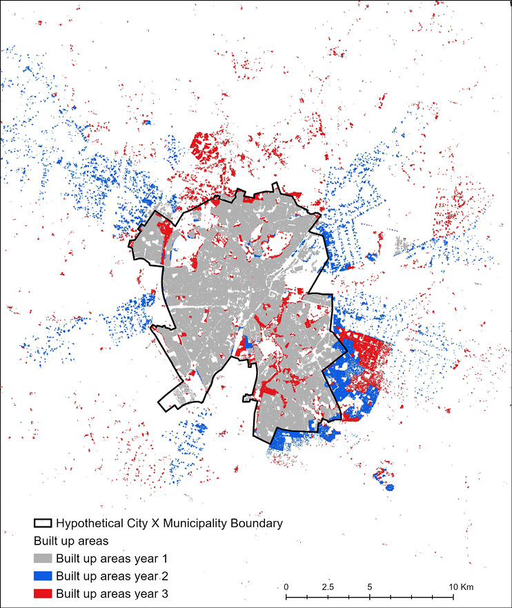
Fig. 1. Built-up area change in city x
Source: own work.
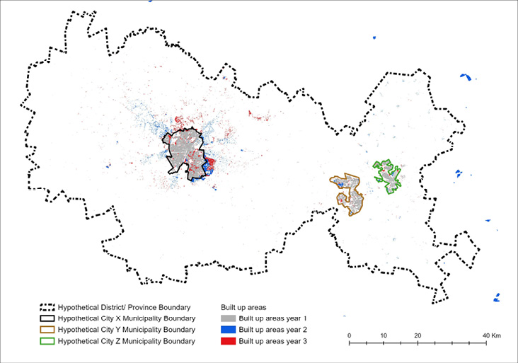
Fig. 2. Built-up area change in cities with region q
Source: own work.
Conversely, the governance structure for the sub-national unit where expansions of the different municipalities are occurring may face uncontrolled urban-threshold developments, displacing fertile agricultural areas. Without looking at the two levels of analysis (city and sub-national), the municipality mayors and policy makers in the larger region would be faced with a dilemma of finding the most suitable solutions to their unfolding challenges. Examining the two levels of analysis jointly would immediately create a basis for the leaders to work together and formulate collective solutions which might include agreements to expand the municipality boundaries and implement strategies on planned city extensions. In foresight, they might also agree to create a regional development strategy, which would make the necessary provisions for the co-existence of the urban and non-urbanised land uses, with overall positive impacts to the region’s sustainability. Within the individual municipalities, the mayors would be able to see the types of developments happening at the neighbourhood level, and put in place relevant strategies to ensure that the quality of life of their citizens is not compromised, but instead ensure coherence and planning that maintains the city’s urban sustainability form.
The above scenarios are typical of what we see in many regions and countries and this demonstrates the relevance of multi-level analysis at the sub-national, city, and neighbourhood levels, and how this can directly contribute to joint policy formulation and decision making. They also highlight the relevance of examining sustainability with a system-wide lens, which helps understand how different elements of the living/built environment interact with the natural environments, and the needed actions to ensure harmonious development. Today, such analysis can be easily implemented from freely and openly available satellite imagery and processing resources, but also using global datasets such as Global Human Settlement Layer (GHSL). Similar analysis requirements are embedded within the SDG 11 monitoring framework (indicator 11.3.1), as well as in the New Urban Agenda. Both frameworks establish that, to become sustainable, cities require orderly development which can be fulfilled through effective planning, formulation, and implementation of relevant urban policies, sound environmental protection, and strategic investment actions intended to meet the needs of the current and future generations. Such interventions should be informed by a multi-level analysis of the spatial trends of urban areas.
The need for multi-level analysis also crosses other aspects of urbanization. Over time, the multi-level analysis has helped the global community to better understand the effects of spatial location which sometime can also be gendered. For example, women in cities tend to be more constrained than men in accessing some services and benefits of the city. In cities of both the developing and developed countries, there are numerous recorded incidences showing women are more vulnerable to the risk of harassment and violence in public spaces and also while accessing public transport (UN Women, 2020). In addition, urban crime and violence rates tend to be concentrated where low income communities are also spatially concentrated. Crime has a detrimental impact on development by increasing costs and by eroding the value of household assets or properties. In US metropolitan areas, for example, households from poor neighbourhood are around one-third more likely to be the victims of crime than those from rich suburbs; and in such neighbourhoods, property crime rates are two to three times higher and murder rates are five times higher than elsewhere (Valdez et al., 2007).
In many cities, the spatial distribution of welfare indicators is caused not only by spatial inequalities in income; it is entrenched by regressive spatial distributions of public investment (Kilroy, 2007). One of the most influential causes of spatial inequalities is increased lobbying (group competition) for public expenditure on services and amenities, with higher-income groups having a higher bargaining power compared to poorer neighbourhoods. These discrepancies in public expenditures on communities are augmented further by the fact that among high-income areas there is a larger propensity to provide their own physical and social infrastructure privately.
More broadly, there is also a lack of intra-urban information and limited capacity among urban institutions which impedes policies to mitigate the effects of spatial inequalities. Many cities in the developing countries are handicapped from effectively developing informed urban policies and analysing their implication due to a lack of capacity and frameworks for monitoring the data to study the margins of differences. Without better information, city administrations and national governments cannot systematically appraise urban problems, and if they engage in remedial policies, they cannot effectively measure their outcomes. Indeed, data measuring the internal spatial structure of the city, its economy and the distribution of opportunities is not even collected in many parts of the world today.
Addressing urbanisation and leveraging its opportunities requires a clear understanding of city level trends, and urban-suburban-rural areas (urban continuum) interactions. This also requires working across a variety of actors to ensure that data is transformed into knowledge that supports local actions and policies. UN-HABITAT’s work in supporting continuous urban monitoring against the sustainable development goals (SDGs), and the New Urban Agenda is a good example where a harmonised urban monitoring framework that integrates space-science-based measurements, particularly those which rely on satellite imagery for land cover/ land-use classification and built-up areas extraction has been developed. The framework is applicable at the neighbourhood, sub-national, national, and global levels (United Nations, 2022a). Where the framework has been applied, the information extracted from the analyses has been used for indicator specific applications, such as understanding urban trends, population distributions and their proximities to urban spaces and services, understanding of spatial inequalities and climate risks, among others; all of which directly contribute to the agenda of leaving no one and no place behind.
In summary, a multi-level analysis that is designed to facilitate transformative policy shifts entails significant and fundamental changes in the approach or direction to embrace innovative and bold measures to bring about substantial change. It involves adopting new strategies, principles, or frameworks that can profoundly alter the way in which policies are designed, implemented, and financed. The scale, complexity, and multi-dimensional drivers of urbanisation certainly call for transformative shifts that depart from the status quo/business responses. The fulfilment of transformative shifts requires collecting the most relevant data at scale alongside dedicated political will, policy continuity, and policy agility to bring about the desired changes.
The inclusion of Sustainable Development Goal (SDG) 11 and various other urban-related SDGs targets in the 2030 Agenda for sustainable development and the strong connections with the New Urban Agenda is a recognition of the intrinsic value that cities hold today in the achievement of global goals (United Nations, no date). The multi-layered level of recognition embedded in the SDGs and the New Urban Agenda where actions need to cascade from local-national to global is a key lesson drawn from some of the strategies that followed the transition from the Millennium Development Goals. Whilst cities are incredible generators of economic growth and well-being for many countries, often they are also centres with neighbourhoods where poverty and inequality are manifested in greater magnitudes. Yet, if cities are properly planned and well-managed, urbanisation processes can reduce poverty and inequality – for example, by creating employment opportunities, as well as ensuring access to infrastructure and basic urban services, especially for the most vulnerable. However, in many cities, progress towards equality is constrained predominantly by shortcomings in urban planning and design, and the consistent lack of data to understand the nature and distribution of the problem, as well as the prevalence of land-use policies that fail to address spatial inequality (UN-HABITAT, 2018).
The lack of spatial data is a major bottleneck for designing and setting evidence-based policies and priorities for cities. However, based on the available data one can conclude that the nature and impacts of urban poverty and inequality in cities is not homogenous. Trends differ significantly between cities of developed and developing countries, which reflects the reality of a highly unequal urban world (United Nations, 2022b). However, even with cities from the same countries or neighbourhoods from the same cities we see many spatial inequalities around access to adequate housing, transport, water, sanitation, and other urban-related opportunities.
A multi-level analysis and governance arrangements are today well recognised instruments for creating synergies, reducing overlapping and critical gaps between institutions, and promoting trust and accountability that enhance policy coherence. The establishment and operation of effective and efficient multi-level analysis and governance at the local level requires clear divisions of labour, powers, responsibilities, and resources among national and sub-national government entities. It also requires multi-stakeholder collaboration among government institutions, private firms, civil society and other NGOs, higher education institutions, and other innovative partnerships at all levels. Since 65 percent of the SDG agenda may not be fully achieved without the involvement of urban and local actors, delivering all SDGs rests on the actions of local governments and the existing multi-level connections and governance structures of support from the national governments.
EUROPEAN UNION, FAO, UN-HABITAT, OECD, THE WORLD BANK (2021), Applying the Degree of Urbanisation: A methodological manual to define cities, towns and rural areas for international comparisons, https://unhabitat.org/sites/default/files/2021/12/ks-02-20-499-en-n.pdf [accessed on: 17.03.2023].
FLORCZYK, A., CORBANE, C., SCHIAVINA, M., PESARESI, M., MAFFENINI, L., MELCHIORRI, M., POLITIS, P., SABO, F., FREIRE, S., EHRLICH, D., KEMPER, T., TOMMASI, P., AIRAGHI, D. and ZANCHETTA, L. (2019), GHS Urban Centre Database 2015, multitemporal and multidimensional attributes, R2019A. European Commission, Joint Research Centre (JRC) PID, https://data.jrc.ec.europa.eu/dataset/53473144-b88c-44bc-b4a3-4583ed1f547e [accessed on: 17.03.2023].
KILROY, A. (2017), Intra-urban spatial inequality: Cities as “urban regions”. World development report –Reshaping economic geography background paper, https://rrojasdatabank.info/Kilroy2.pdf [accessed on: 17.03.2023].
MUDAU, N., MWANIKI, D., TSOELENG, L., MASHALANE, M., BEGUY, D. and NDUGWA, R. (2020), ‘Assessment of SDG Indicator 11.3.1 and Urban Growth Trends of Major and Small Cities in South Africa’, Sustainability, 2020, 12 (7), 7063. https://doi.org/10.3390/su12177063
UNITED NATIONS, DEPARTMENT OF ECONOMIC AND SOCIAL AFFAIRS (no date), Sustainable Development. The 17 Goals, https://sdgs.un.org/goals [accessed on: 17.03.2023].
UNITED NATIONS, GENERAL ASSEMBLY (2015), Transforming our world: the 2023 Agenda for Sustainable Development. Resolution 70/1, https://documents-dds-ny.un.org/doc/UNDOC/GEN/N15/291/89/PDF/N1529189.pdf [accessed on: 17.03.2023].
UNITED NATIONS, GENERAL ASSEMBLY (2017), Work of the Statistical Commission pertaining to the 2030 Agenda for Sustainable Development. Resolution 71/313, https://documents-dds-ny.un.org/doc/UNDOC/GEN/N17/207/63/PDF/N1720763.pdf [accessed on: 17.03.2023].
UNITED NATIONS, HABITAT III SECRETARIAT (2017b), New Urban Agenda, https://habitat3.org/wp-content/uploads/NUA-English.pdf [accessed on: 17.03.2023].
UNITED NATIONS, UN-HABITAT (2018), SDG 11 Synthesis Report 2018: Tracking progress towards Inclusive, Safe, Resilient and Sustainable Cities and Human Settlements, Nairobi.
UNITED NATIONS, UN-HABITAT (2018b), SDG Indicator 11.3.1 Training Module: Land Use Efficiency, Nairobi.
UNITED NATIONS, UN-HABITAT (2022a), The Global Urban Monitoring Framework, https://unhabitat.org/the-global-urban-monitoring-framework [accessed on: 17.03.2023].
UNITED NATIONS, UN-HABITAT (2022b), World cities report 2022: envisaging the future of cities, Nairobi.
UNITED NATIONS, UN-HABITAT (forthcoming 2023), SDG 11 Synthesis Report 2023: Tracking progress towards Inclusive, Safe, Resilient and Sustainable Cities and Human Settlements, Nairobi.
UN WOMEN (2020), Research highlight. Gender and COVID-19. COVID-19 exposes the harsh realities of gender inequality in slums, 14 May 2020, https://data.unwomen.org/features/covid-19-exposes-harsh-realities-gender-inequality-slums [accessed on: 17.03.2023].
VALDEZ, A., KAPLAN, C. D. and CURTIS, R. L. Jr. (2007), ‘Aggressive Crime, Alcohol and Drug Use, and Concentrated Poverty in 24 U.S. Urban Areas’, The American Journal of Drug and Alcohol Abuse, 33 (4), pp. 595–603. https://doi.org/10.1080/00952990701407637